Saturday, June 15, 2024

Sunsets & Internet Limbo

 June 10 thru 12 Location: Potato Hills Central Campground (COE); Clayton, Oklahoma

June 13 thru 15 Location: Cowlington Point Campground (COE); near Salisaw, Oklahoma

This blog post covers two campgrounds because I'm in an internet limbo area of Oklahoma. Without internet, I couldn't make a post from Potato Hills since I had zero service there. I thought it would be better at Cowlington CG since it is about a hundred miles north of Potato Hills. I was only half right, I am only able to receive 1 bar of service and it comes and goes here. After checking Verizon's coverage map, it seems they have many holes in their coverage in Oklahoma. One of the reasons for weak signals is because a smaller cell service provider was in the area which limited my access to the Verizon system. I'm not sure about that but I know I've went through heavy withdrawal without internet access. That has me questioning my reliance on such a vulnerable system. I count on it for family connection, banking, weather, route planning (GPS), the blog, games, news, alerts, campground information, restaurants, gas station locations, Walmart and any interesting question that pops in my head. With such a vast amount of information literally at our fingertips, why is the younger generation that grew up with that access so naive and ignorant about so many things. What happened to the promise of Nationwide Rural Broadband coverage after Congress passed the Infrastructure Bill of 2021? Nevermind, I know the answer to that. Certain people have to fill their pockets before there is any "excess" money to fulfill promises. Wow, who knew I was so jaded. LOL I'm beginning to question if it has something to do with being in the middle of the Indian Nations. I'm in the Cherokee Nation now but just left the Choctaw and Chickasaw Nations. I will try to do a re-cap of all the Native tribes I've visited after I leave Oklahoma. Hmmmm,,,,inquiring minds want to know. :)


The drive to the Potato Hills CG looks a lot like my part of Louisiana, except for the occasional mountain.


It was a good campsite at Potato Hills CG. The trees didn't provide much shade, but looked good. 

The campground had at least one hundred geese living there. They left behind parts of themselves which I initially blamed on small dogs and complained about campers not picking up behind their pets. Oh well.

This is the view out my back window. The geese would swim by early in the morning then again late in the evening. 


Campground at Cowlington Point CG. It was a nice campsite with a great view but the setting sun hit me broadside. Since it is setting over some trees, it wasn't a nice looking sunset.

View out my back window. Very peaceful (I guess it has to be since there isn't any internet,,,, my attitude slipped out again)


This is a memorial bench to an individual. His name is on the bench with a few other nice words. I took a picture of the words but decided not to post it here. It just didn't feel right. This is only the second time I've seen such a thing in a Corps of Engineers Campground or property. It's a rare thing in deed. He must have been a good guy. He knows all of the answers now. 

As usual, there were two reason for coming to the Potato Hills Campground. The first was to ride a portion of the Talimena Scenic Highway. I had ridden a portion of it when staying at Queen Wilhelmina State Park near Mena, Arkansas earlier in the year. I knew I wanted to ride more of it on the Oklahoma side and this campground provided that opportunity although it was a 100 miles round trip of exploring. It worked out perfectly because two of my grandkids were spending the night with my X-wife (yeah, still friends) so I was able to facetime with them at several of the scenic vista pull-outs along the highway. I enjoyed it so much, I forgot to take pictures for myself of the first few stops. It was a nice ride on top of some of the Ouachita ("wash-a-taw")Mountains with stops to view the valley below. Except for two other travelers, I was alone for at least 30 miles of the scenic highway.


A nice view. Most people think Oklahoma is dry and flat land and it is in places but not everywhere.


You can have a picnic with a view

Or a picnic with shade trees

The second reason for my trip was to visit the Choctaw Nation Capitol. Strangely, it is located in this very rural area. After the Civil War, one of the Choctaw chiefs suggested the name "Okla Humma" for the area. It means "people who don't retreat". Eventually, it became the state name,,,Oklahoma. They have a very nice museum located in the old capitol building that was built in the 1800's. Museum ranking 6 out of 10. Wow, more of my "jaded-ness" coming through. I got to work on that.


This building is the Choctaw Nation Capitol. It was built in 1884 using local materials. Meaning, the bricks were made and fired in kilns built for this building. Sawmills were set up nearby to cut the dimensional lumber. 

And as a bonus, my campsite Potato Hills was situated right on Sardis Lake with the back end of Liberty looking right at the setting sun location. We were rewarded with two really nice sunsets. 

The bird in the upper center is a Scissor-tailed Flycatcher,,,,the state bird of Oklahoma. He/She visited the bushes located at the back of Liberty and I could watch them out my back window. 


The beginning of the first sunset

The first sunset as I was walking around the campground.


The first sunset on Day one at Potato Hills


This is still the first sunset. I couldn't decide on which picture to post.

This is the second sunset on day 2 at Potato Hills.

Except for the lack of cell service which means no internet, they were very nice and relaxing stop. Lot's of thinking time, even without a bench.

Tomorrow is moving time and I head about 100 miles north to another COE campground near Tulsa. I'm thinking I'll have strong internet there, but I ain't taking any bets.  

Ya'll take care of each other. Maybe I'll Cya down the road. 

Sunday, June 9, 2024

A Dam, Choctaw & Chickasaw

 Burns Run West (COE) Campground; Denison, Oklahoma about an hour or so north of Dallas, Texas

Another nice Corps of Engineers Campground that attracts a lot of people from Dallas, Texas which is located within an easy drive. There are a little over 100 campsites in this campground and it is only one of others on this lake. Combined with the giant Choctaw Indian Casino in Durant about 20 minutes north, it was a busy weekend. It appeared that every campsite was occupied but as of late Sunday, it is down to about 20%. 

Typical open field in rural Oklahoma


Home for three days. It may look shady, but the afternoon sun found a hole in the trees for a few hours in the afternoon.

The campground is on the banks of Lake Texoma which is the 12th largest COE lake in the country. The dam was built in 1944 on the Red River with the Washita River being a major tributary. The dam itself is unique in that it is the first "rolled earthfill" dam in the world. That means it was built in lifts of soil about one foot thick and rolled with heavy machinery. The vast majority of earthfill dams and roadways have been built that way every since. The dam is also a hydro-electric dam with two large external surge tanks. Some hydro dams don't have such highly noticeable surge tanks. I believe these two are also "topless" (open to the air on top). The 30,000 acres that was to be impacted by the lake was cleared by about 200 German POW's from World War II. They cleared it all with the use of axes and saws (no heavy machinery). That's a lot of information crammed into one paragraph,,,,,whew.

This is the back side of the dam. That's the powerhouse on the left with the two large surge tanks. The tanks can be "topless" because physically, the lake water level can never be higher than the top of the tanks. 


I even found a nice "thinking bench" although the grass needs trimmed. 

I had two items to explore in this area, not including the dam/lake. The first being the Fort Washita National Site. Like Fort Towson in my last post, Fort Washita was built on what was then the International Boundary and on the edge of the frontier. One of it's main purposes was to protect the Choctaw and Chickasaw Indians from the Plains Indians and White settlers. This fort has much more of the original building foundations than Towson. It is currently being managed by the Chickasaw Nation and the two curators/historians I met were very friendly and knowledgeable. It was a nice stop. I won't rate the museum like I usually do because it was a very small and is not a major part of the site.

The entrance. The grounds were very well kept and is impressive due to the large size of the place.

One of the interesting things was a memorial cemetery to 200 unknown Confederate soldiers that died during the Civil War. Notice the correct Confederate flag is flying, not the "stars and bars". One grave to represent 200 unknowns.

The second exploration was the Choctaw Cultural Center located in Durant. It is very modern and very large. Everything you could possible want to know about the Choctaw Nation can be found in this location. I wandered around learning different things for a couple of hours and could have stayed a couple more except I was getting overloaded with information. If you decide to go to this place, be prepared to spend the whole day. I had seen online that they have a cafe inside that makes some Native foods but I had forgotten and ate before I arrived. Everything smelled really good though. Great information. Museum rating, 8 1/2 out of 10.

Very modern and big.

It was hard getting pictures inside or it's possible that I forgot because I was trying to absorb all the information. 

Tomorrow is moving day and I'll be headed about 100 miles north looking for some cooler weather. Today's high here was 96 with a heat index of 103. But the forecast shows temps in the mid to low 80's where I'm headed to next. There is still strange weather going on. There is a storm about to hit the campground in a few minutes and according to radar, it's coming out of the north instead of the west as they usually do this time of year. Oh well, Liberty is mostly watertight, so let it rain, just keep the tornadoes away from me. 

Ya'll take care of each other. Maybe I'll Cya down the road.    

Friday, June 7, 2024

Dinosaur, Steamboat & A Fort

 Location: Virgil Point COE Campground; Sawyer, Oklahoma on the banks of Hugo Lake

Another nice Corps of Engineers campground and a campsite right near the water. The campsite isn't situated so the setting sun is directly out my door, but that's OK. Today is day four and is moving day. A heavy thunderstorm blew through on the first night here resulting in the lake rising maybe two to three feet over the last couple days. It was strange in that the thunderstorm didn't seem to be forecasted on my weather app that I've relied on for years or maybe I just missed it. 

Another nice campsite for $11.00 per day


The view back to Liberty from up the hill by the boat ramp parking lot.

I took this one this morning of the sunrise while looking out my door.


This is the view out my back window as I'm typing this post on my laptop. The great thing about moving campgrounds often is this view will be different this evening. I hope the next one is as peaceful as this one is this morning.

Although a nice campground, I don't get great vibes from it. Something just feels a little out of place or out of sync. It's just a feeling and I haven't experienced anything physical. If I had the time, I would research to find the reason for such a strange feeling in such a pretty place but since today is moving day, I'll just move on and stay blissfully ignorant. I know I won't be back here though. Just to be clear, it's not a fearful feeling, just an uneasy feeling. Maybe I'll listen to the Eagles song Peaceful Easy Feeling on the way to the next campground.

I had two things I wanted to explore while staying here. The first was Fort Towson. The old fort site is maintained by the Oklahoma Historical Society and they have recovered some of the old fort with plans for more recovery in the future. Although it was too wet and muddy to walk around the old fort site, they have a pretty good museum. Being a veteran, admission was free. Yeah, yeah I know I'm supposed to be so jaded about museums but I can't resist them. One a scale of 1 to 10, I give this one a 6. Pssst,,,by the way I went to another one after this one.

The fort was first established in 1824 to protect the recently arrived Choctaw Indians from attacks by the Plains Indians and white settlers. It is located only five miles from the Red River which back then was an International Boundary with Mexico. Today the Red is the boundary between Texas and Oklahoma. Once Captain Shreve cleared the great raft (100 mile long log jam) from the Red River in the 1830's, steamboats were able to reach Fort Towson and it became an entry point to Mexico and eventually to Texas when it gained its independence in 1836. In 1999, the wreak of the Steamboat "Heroine" from 1838 was found near here in the Red River. Famous people such as Davy Crockett, Sam Houston and Stephen F. Austin passed through Fort Towson on their way south. The Confederates took over the fort during the Civil War (War of Northern Aggression or War for Southern Independence) and became headquarters for the Confederacy in the Indian Territories. It is also the site of the last Confederate General's surrender at the end of the war. There is a lot of history in this small area. Some of that history may account for the bad vibes.

You don't often see maps of the original locations of the displaced Indians as a result of the bad Indian Relocation Act. I took this picture of one in the Fort Towson Museum

A model of the Heroine steamship that sand on the Red River about 5 miles from here.

A replica of the paddlewheel on the steamship. It helps put the ship in perspective 

And staying with history at the museum, they sell historic brand chewing gum. It was a little stale, but surprisingly, the taste brought back good memories of childhood.

The second thing to explore around here is another museum. This one is a much larger one than Fort Towson. It is the Museum of the Red River in Idabel, Oklahoma. Although I explored the whole museum and there are some great things to see and learn about, the main reason I went was to see the Dinosaur. The museum is an art and archaeology museum with free admission thanks to some deep pocket philanthropists who may be trying to appease a guilty conscious or they may just simply be nice people. It was a nice place with good vibes so I'll go with the nice people choice. The main attraction for me was the dinosaur. It is a Acrocanthosaurus atokensis. It looks like a T-Rex. It was found nearby and was dug up by some amateurs in 1940. The original was sent to a laboratory in South Dakota for preservation since it was disintegrating quickly once exposed to the atmosphere. The neat thing is the dinosaur replica we see today in the museum was paid for by a fund raising event of elementary school children. Pretty neat uh?

Even knowing it was in the museum, it took me by surprise knowing that something like that used to live in this area. Remember, the word "dinosaur" has only been used since around 1840. Before that, they were known as "Dragons".

It was a pleasant surprise finding a bench like this in the museum. I didn't sit on it though because it had such a shine to it I was concerned that if I sat down I would slide off and bust my behind. It wouldn't be the first time, but would be embarrassing.  

 Like I said, today is moving day. I'll be heading about 90 miles west of here to another COE campground on Lake Texoma which is about 1 1/2 hours north of Dallas. Nope, I won't be going to Dallas. I've been there, mainly to check out the JFK assassination site and since I didn't lose anything there, I don't need to go back.

I wasn't able to get any real good sunset pictures but was able to get this one through some trees. It's from the parking lot of the boat ramp just up from my campsite. 


I promise, there is a sunset there somewhere. Anyway, it was a nice evening walk around the campground.

Ya'll take care of each other. Maybe I'll Cya down the road. 

Tuesday, June 4, 2024

Lake 'O The Pines & Storms (mostly pictures)

 Location: Buckhorn Creek Campground (COE); Jefferson, Texas

After three days, today is moving day. This is the second time I've been to this campground and the third time I've camped along this lake. It is conveniently located and has a good vibe. Since I've been here before, I didn't do much exploring. Jefferson, Texas and the surrounding area is pretty interesting and worth exploring. If you want to know more about the area, the following links are to my blog posts from my past stays here:

https://gozatravels.blogspot.com/2023/02/lake-o-pines-coe.html

https://gozatravels.blogspot.com/2023/02/exploring-jefferson-texas.html

https://gozatravels.blogspot.com/2024/02/another-great-coe.html

Storms have blew through this area every evening that I've been here. My campsite is situated so when looking out my door, I'm looking west. I chose this site for that reason since I was hoping to see some good sunsets. I was surprised that I got 2 descent ones in between storms. The west is also the direction the storms were approaching the campground as they passed over the lake. They aren't as powerful and beautiful as the one I caught blowing in over Lake Michigan many years ago, but they were OK. These storms have been hitting the Texas/Arkansas/Louisiana/Oklahoma area from more than a week. I can't remember ever seeing this weather pattern. The other strange thing I've noticed is the thunder sounds different. It seems to roll on much longer than it use to. I've heard some recently that lasted well over a minute or two. One lasted so long in fact, that I heard it rumbling and thought, "what the heck is that" before realizing it was from the thunder clap a long time before. That instance and many more happened before I left Louisiana and it is occurring here in northeast Texas. Strange. Something to keep and eye on or maybe an ear. 

This is the campsite in Louisiana that I pulled out of on June 1st. I'm posting it here for comparison to my current campsite.

I remember that some of the readers enjoy the travel pictures through the windshield so they can see the different parts of the country. This is a two lane section of a Texas state highway in northeast Texas. 

My campsite here at Buckhorn Creek with Lake 'O The Pines in the background. West is directly over Freedom and the direction that the storms are coming from. It was a very pretty day and the weather was great as I set up camp.

This is the sunset I was rewarded with on the evening of Day one. A batch of storms had just passed over as the sun was setting.

This is the same sunset as the one above but in this one I captured a little bit of the storms clouds as they were headed east. 

The afterglow of the sunset from Day one. The storms had just passed, the winds died down and the lake got peaceful from the night.

This is the morning of Day two. Looking out of Liberty's door showed a peaceful looking morning with a gentle cool breeze. Very nice. The storms came about an hour before sunset and lasted a couple of hours.

This is the storm that blew through yesterday evening (day 3)

I almost forgot to get a picture out my back window. This is my view when I'm using my desk.

This was last night's sunset. It really surprised me. I thought for sure the storms were going to block any view of it. I had given up but then I caught a glimpse of something red that looked like something was on fire. Wow, the sun was fighting through the clouds and it was spectacular. My cell phone camera couldn't pick up the deep red of the sunset. I'll have in my memory though.

The storms have kept me mostly inside Liberty while here but I did get one walk in around the campground. Being stuck inside means lots of thinking and even without a "thinking bench". Wow, would that be considered "thinking outside of the box"? I figure today's tow of about 135 miles with a Walmart stop for groceries will help clear my head. Maybe not clear it, but a little organization would help. The good news it isn't the old "memory demons" because I've kicked their butt and sent them off to a corner. Nope, these thoughts are more contemporary. 

I learned a lesson from last night's sunset. I've always liked storms for their power and always liked sunsets for their beauty. Last night I learned you can have both at the same time. This lesson doesn't only apply to storms and sunsets. It's one of those things that make you go,,,,,"hmmmmm". 

Ya'll take care of each other. Maybe, I'll Cya down the road.

Friday, May 31, 2024

Trip Begins Tomorrow

Location: Heart of Haynesville RV Park; Mansfield, Louisiana

I shove off tomorrow with storms predicted for tomorrow and the next couple of days. I've done this several times over the years and most of the times it worked out just fine. It takes me about 15 minutes to gets things ready to travel inside of Liberty and then another 15 to 20 minutes of outside work. Since the weather forecast predicts storms at random times, I will have to find about 20 minutes of no rain, or at least light rain to hitch up and hit the road. I did it once in a heavy rain while wearing a rain poncho and that wasn't fun. I won't have to do that tomorrow since I will be able to leave anytime between 10:00 am and 3:00 pm with plenty of time to spare. The storms are predicted at the campground as well, so I may be setting up camp in the rain. I hope not. 

Storms hit this campground yesterday evening with a tornado passing within 1/2 mile. There were some straight line winds and heavy rain hitting Liberty broadside. It was bad enough that rain was being forced through the vent stack of my refrigerator. I had to sop up about a gallon of water. It was in the top 3 of the worse storm I've ridden out in my RV. Not as exciting as "rocking and rolling" during a storm at sea in the Navy, but close. 

I have reservations made all the way to the Rally in Goshen, Indiana. I had to modify one due to tornadoes/storms taking out 3 COE campgrounds near Rogers, Arkansas. I had reservations at one of those so I had to change to another one. Everything happens for a reason so we will see. 

I'm looking forward to the trip since I've been stationary for two months. Strangely, my excitement level is only about 80% of what it has been in the past. (geez,,, calling out a percentage of excitement. Is my engineer mentality showing????). I don't have any planned exploration for the three days at the first campground and plan to just ease into traveling again. Like a shakedown cruise but without the hand grenades being tossed over the side. Some X-sailors will know what I'm talking about. 

This is a boring post, but I wanted to make it to document the start of the trip. Hopefully, they will improve once I get on the road and get in a traveling frame of mind.

I can't do a post without a picture. The one I've chosen for this post is from the California coast probably back in the early spring/late winter of 2015. I liked it a lot so I added some words to it. 

A solitary walker on a deserted California beach early in the season with still a nip in the air. I wished I knew what she was thinking when I took the picture. I added the words because that phrase is what I was thinking about at the time. 

Ya'll take care of each other. Maybe, I'll Cya down the road.   


Monday, May 20, 2024

Route & Shove Off Date Chosen; 20 Reservations made

 Location: Heart of Haynesville RV Park; Mansfield, Louisiana

As I said in my last post, I've registered for the big Forest River International Rally in Goshen, Indiana. It begins August 11th and lasts one week. That established my long range destination. The next step was to choose a date to leave Louisiana. While typing this post I was reminded of the term 'shoving off' from my old Navy days. I would imagine some old Coasties that used to RV may be familiar with the term also. Since my campsite rent here in Louisiana is due on the 1st of the month, there seemed to be two possible dates, either June 1st or July 1st. To break that tie, I went to Accuweather and noticed the fore-casted temperatures for the end of May around here were in the low 90's. It appears the warm and humid summer is getting here quicker than normal. So, June 1st was chosen. 

Between June 1st and August 11th is about 70 days. On this type of trip, I usually average about 3 to 4 days per campground so that means I will need to make reservations at about 20 campgrounds just to get to Goshen. With so many stops, I have found that most of the time if I find a nice campground, I can usually find something to explore or will accidentally find a "wow" moment within about a 50 mile radius. If not, I'm only there for 3 to 4 days, so I'm not being too lazy by just hanging out at the campsite. This may sound backwards about finding a campground first instead of things to explore. Oh well, if things start sneaking up your backtrail, it is best to do some things unconventionally.

Corps of Engineers (COE) campgrounds continue to be my favorite and first choice. My Allstays program on my laptop locates them for me. Google Earth will then be used to choose not only the best COE campground in an area but, most of time, the best campsite. If the campsite is visible from above, Google Earth will also tell me approximately how level the campsite is, its dimensions and cardinal direction of the campsite. That is how I've been able to chose campsites with the setting or rising sun coming in my door or back window. The web site, "recreation.gov" will usually give me pictures of the COE campsites. This all sounds complicated, but it really isn't, after you get used to it. 

The route I've chosen has 14 COE's and 6 State Parks. I wish I could have stayed in COE's for the entire trip but they rare or non-existent in Indiana, northern Illinois and Ohio.

That's the route I've chosen. It is about 2,000 miles of towing which means an average of 100 miles between campgrounds. I have reservations locked up except for the last two. I'm still debating with myself which ones those will be. I'm waiting for a good vibe to hit me. 

 
This is the second descent sunset I've gotten since being back home. Yeppers, the picture is taken while looking out my doors. 

Ya'll take care of each other. Maybe, I'll Cya down the road.


Thursday, May 9, 2024

Which Direction? & Random Thoughts

 Location: Heart of Haynesville RV Park; Mansfield, Louisiana

I've been back at my home-base since April 1st which is about 5 weeks. I've seen one doctor, did a little RV maintenance and a few visits with grandkids, kids and X-wife. Some of you readers may be shocked that I've visited with my X-wife, but we are friends. There isn't a lot wrong with that and it only makes be a little bit crazy for being friends with her. But golly-gee Batman, it is hard not to be friends with someone that you were married to for 28 years and raised three children. Oh well, my hope for ya'll with X's is that if you can't be friendly, at least be respectful because life is short.

I got lucky in getting my old campsite. I drains well, is level side to side and a view of the west out my door.
 
It is sad that I've only gotten one descent sunset out my door since I've been back.


There has been a few "strange" storms since I've been back. One storm blew a tree onto the slide-out of this RV in the campground. I haven't heard if anyone was hurt or not. It is only a few campsites from where the RV burned down when I was leaving on my last trip. Bad ju-ju in this part of the campground.

After five weeks in one place, even home-base is a long time for me. I don't have a bad case of "hitch-itch" yet and that has me a little concerned. I've registered for the very large Forest River RV Rally in Goshen, Indiana. This will be my fifth year to attend. It is scheduled to begin on August 11th and last one week. My plan is to leave here on June 1st before the heat sets in and take my time getting to Indiana. I'm having trouble coming up with a route to take.

For those who wanted to see some Cypress trees with Spanish moss, here you go. This is Clear Lake which is a local lake.


This is looking out at the Red River from the boat ramp near Lock & Dam #5. I'm still disappointed that the Corps of Engineers didn't build any campgrounds when building the L&D's on the Red. 

You can tell you've been a fulltime traveler for too long when you start thinking about things like,,, "I could head out west to see the Rockies, then swing east through the Badlands of the Dakotas and maybe go through the Upper Peninsula of Michigan before dropping down to north east Indiana for the Rally." Then I start second guessing by saying, I've been to all of those places and do I really want to repeat? Or, "Maybe I could head east to the Outer Banks of North Carolina then up to Pennsylvania to check out the changes to the Flight 93 Memorial since the last time I was there before swinging over to Indiana for the Rally". Except for the Outer Banks, I've been to all of those places too. 

If I leave on June 1st, I need to start making campground reservations soon. After doing a quick review, I discovered the National Park campgrounds on the Outer Banks, the Indiana Dunes and Sleeping Bears Dunes park in Michigan do not have electricity at the campsite. In the summer, that is a big NO for me. Maybe in the off season, but not the summer. So that was a big disappointment. I looked at some private campgrounds near those National Parks but was shocked at the prices. Most started at $50.00 per night. Wow, I might do that for one or two nights in a very special place but not for 5 days or so. I then checked out some state parks and found the price for them had also went up since the last time I had stayed in that state. After looking at 3 or 4 states, the average price starts around $35.00 per night. For those of ya'll that are wondering, I can routinely get a great campsite with a perfect view and location at a Corps of Engineers campground for an average of $11.00 per night. I'm afraid that is going to change though and sooner or later, people like me will be priced out of traveling around the country. 

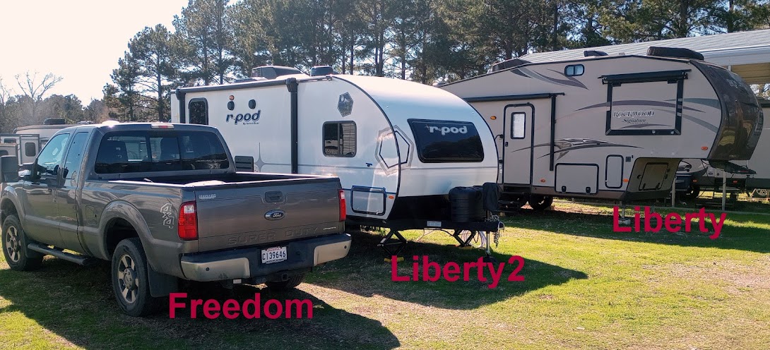
I still have the freedom to go where I please, whenever I want to go. I will never take that for granted because I know one day I will have to permanently park Liberty and hang the keys to Freedom up. I suspect that time will come suddenly and without much warning. That will be a tough time. It will be the opposite feeling of extreme freedom that I got when I first got my drivers license as a teenager. I am not looking forward to losing my Freedom and will hold on to it with both hands. Like Dylan Thomas wrote, "Rage, rage against the dying of the light". 

I started this post a few days ago and I still haven't began making reservations. Thoughts have crept into my head about postponing departure date until July 1st but when I look at the weather forecast for here in July and see 95+ degree days, I quickly revert back to June 1st. I am still "iffy" about the route but am leaning to heading up through Oklahoma, Arkansas, Missouri, Iowa, Illinois, Michigan then the Rally in Indiana. 

I will post my route with reserved campground in my next post.

Ya'll take care of each other. Maybe, I'll Cya down the road.