Friday, May 29, 2015

Last Looks at Bear Lake and Moving Day to Yellowstone

Location: Moutainside KOA (el. 6,800 ft); West Yellowstone, Montana

(click pictures to enlarge)
(all pictures taken with Nokia Lumia 929 cell phone)

I left Garden City early yesterday morning with a 275 mile trip ahead of me. At that distance, it means a fuel stop with Liberty in tow. One of the things I've found in my travels is that Exxon does the best job at positioning their gas pumps so a vehicle with a trailer in tow can reach the pumps and easily get back on the road. Some of the big truck stops like Flying J or Pilot are good for diesel vehicles with tows, but they didn't pay enough attention at the gasoline pumps. I found a nice Exxon to fuel up and a Walmart for some groceries. Other than about 100 miles longer than I like to travel in a day, the trip was nice. It rained a little but not too much. I didn't get many travel pictures this time and I'm not sure why not. Hmmm,, I'll have to think on that one.

I have been waiting for the weather to clear in the Yellowstone area before coming here and it finally looks like I'll have a few nice weather days to explore the park. I wanted to get here early in the season to avoid most of the summer-time crowds. I drove into town yesterday after getting Liberty set up and there were a few tourists visiting the shops, but not too many. 

I'm making this post while I drink my morning coffee. I'll be heading to the park, specifically to the Old Faithful region, this morning. I've downloaded my pictures to my laptop to make room for the ones I plan to take today in the park. The weather forecast looks pretty good with a high of 61 degrees and a chance of showers this afternoon. The people at the campground told me it was a very mild winter in terms of snow and temperatures. Everyone is expecting a larger than normal amount of animals due to the mild winter. I'll see about that today. 

Well, I'm finished with my coffee, time to shower and go. Hopefully, I'll have some great pictures for the next post, but until then, here are a couple from Bear Lake and the trip yesterday. 
Bear Lake. It was a pretty blue

A drive around the lake

Nice

A few birds out for a swim

This is the view I had while hitching up yesterday. The sun was coming through in places and lighting up certain areas. It was like a spotlight shining down. It was interesting.

I found a bench with a couple of
bears holding it up. It will be interesting
for the grandkids to see this picture in
a few decades and I wonder if they
will have seen the Avengers movie. :)

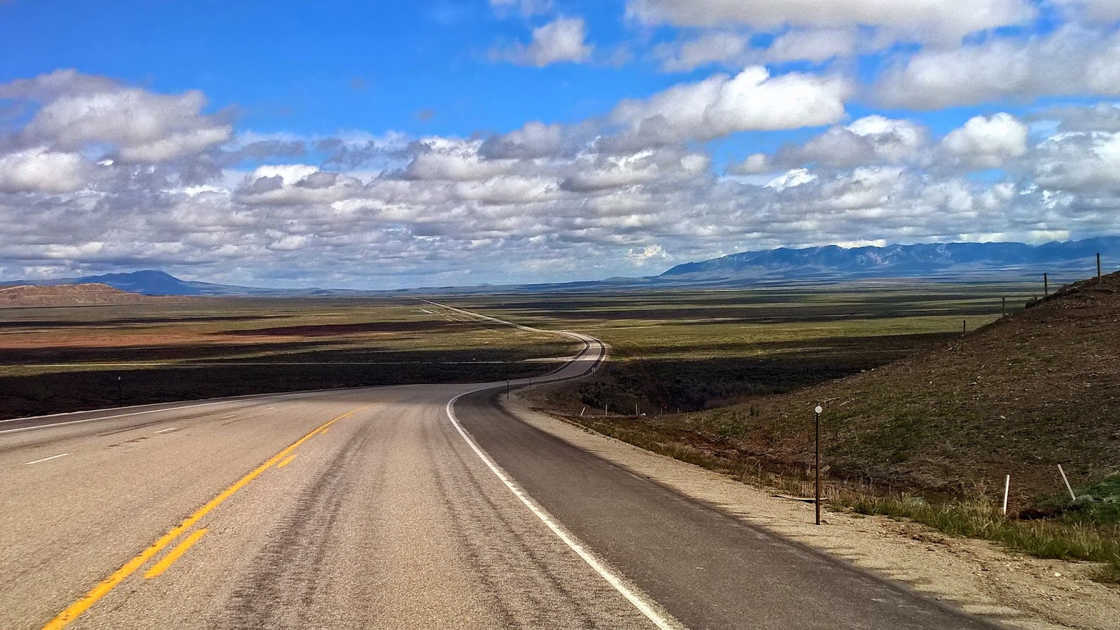
This is the only good travel picture I took yesterday. Ahead, in those mountains, is the Targhee Pass, with Yellowstone just beyond it.

I looked at 3 campsites before finding one that would work. The first two were too muddy due to the large amount of rain they've gotten here in the last week. The one I ended up with is a more expensive one than I reserved, but the lady owner let me have it at no increase in price. That was very nice of her. The upgrade gave me 50 amp service with cable TV. 

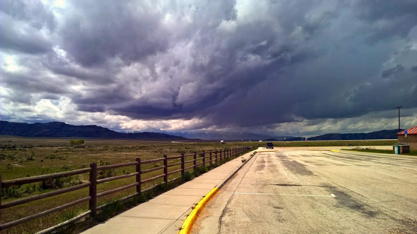
I got this shot as I was returning to the campground from town. The campground is just around the curve. 

Ya'll take care of each other. I'll Cya down the road.

Wednesday, May 27, 2015

The Many Faces of Wyoming on Moving Day (mostly travel pictures)

Location: Bear Lake State Park (el. 6,000 ft); Garden City, Utah

(click pictures to enlarge)
(all pictures taken with Nokia Lumia 929 cell phone)

From Rawlins, there were several different routes to Yellowstone from which to choose. The weather around Yellowstone is due to change for the better in a couple of days so I chose a round-a-bout way of going. While in the Salt Lake City area a few weeks ago, I heard about a pretty blue lake on the border of Utah/Idaho/Wyoming. Of course I needed to see it for myself to compare it to some of the other blue waters that I've seen. So, from Rawlins, I headed due west to just past the town of Little America then headed northwest to Bear Lake. It was a 240 mile, sometimes rainy, trip with a gas and rest area stop along the way. I was surprised by how much the landscape and geology changed in just those couple hundred miles. 

The pictures are in the order they taken so you can see the changes. It was a nice trip.

I got an earlier start than usual. This
was taken around 9:00 am just west
of Rawlins.

About 1 1/2 hours later, the landscape
changed to this.

This is just few minutes from the
picture above and is a few minutes
before going thru the tunnel

I hate going through tunnels. Liberty is 12 ft 4 ins high and I always duck my head when entering while hoping the clearance that is marked is correct. 

This is 2 minutes after exiting the
tunnel. Nice change.

30 minutes later it changes to open
high desert again.

4 minutes after the picture above

15 minutes later, getting into some
rolling hills

same time as the picture above.
It was an isolated homestead with the
nearest neighbor 10's of miles away.

15 minutes past the homestead, the rolling hills are more common with the road finding its way through the valleys between them. This is about 15 minutes from the Utah border.


6 minutes after the picture above, it is
back in to some drier, rougher hills.
The picture didn't pick it up too good,
but there is green grass beginning
to come up on the hill on the right.

Turned off the U.S. Highway and
headed west. It is about 15 minutes
after the picture above and the Utah
state line is in sight. It was a 2 lane,
chip seal road the rest of the way.

It's 10 minutes later and beginning the
climb up the hills. They were higher
than I expected but were still not
a problem for Freedom.


5 minutes later, it is time to go down the other side. The downgrade was a couple miles of 7% grade with two-20 mph curves on that downgrade thrown in for good measure. Runaway Truck Ramps are always a sign to pay attention and maybe put the camera down for a while.

I've been in a lot of pull-thru's
lately so I opted for a back in site.
You can see the lake in the
back ground. 

Home for 2 days 

There are only 4 other RV's in
the campground. I like it.

T
The lake is a pretty blue color but not as pretty as Lake Huron or Crater Lake, but it was still worth the visit.

This is the beach area just a short walk from the campsite. The lake level is down several feet, but they say it should rise in the next several weeks

I took this one this morning as I opened my door to greet the day. The clouds are clearing and even though a few "pop-corn" showers are predicted, it should be a nice day.
One of the more mundane reasons I chose this campground is the paved campsite. I need to slide under Liberty to lubricate the slide and it is always better on pavement than in rocks or dirt. 

I'll leave here tomorrow and should be camped in the town of West Yellowstone tomorrow night. 

Ya'll take care of each other. I'll Cya down the road.

Sunday, May 24, 2015

Devil's Gate and Independence Rock

Location: Rawlins KOA (el 6,750 ft); Rawlins, Wyoming

(click pictures to enlarge)
(all pictures taken with Nokia Lumia 929 cell phone)

I'm hunkered down in Rawlins, Wyoming for the holidays. Campsites are scarce during the major holidays so I made reservations about a week ago. Rawlins is located in the south-central part of Wyoming just off of I-80. The weather forecast for Yellowstone is looking good for the next two to three weeks so I've decided to head that way. I should be there in about 3 to 4 days. 

It was raining when I left Loveland and I drove through it most of the way here. The forecast has a potential for rain almost every day that I'll be here but I got lucky yesterday morning with some good weather. I had hoped for good enough weather to see a couple places north of here. 

The first was Independence Rock. It is a large rounded granite outcropping and is a famous and prominent landmark around here. The Oregon, California and Mormon Trails overlap around here as they converge on the South Pass through the Continental Divide. During a 25 year period between 1844 and 1869, more than 500,000 people passed through this area on their way west. Most of the emigrants would leave Missouri and head up the Missouri River to either Independence, Missouri or Omaha, Nebraska where they struck out to the west along the North Platte River. Most couldn't afford passage on a boat so they walked, using the rivers as a guide. The North Platte River took them across Nebraska and into Wyoming. Around Casper, Wyoming they left the river and began their overland route. The first landmark they used as a guide was Independence Rock which they could see for a couple of days before reaching it. It was common for the emigrants to camp around the rock and some scratched their names and dates into it. Some of those are still visible today. I wonder if the writer of the old movie Red Dawn got the idea about the kids scratching the names of their dead into Patriot Rock from what the emigrants did at Independence Rock.

After passing Independence Rock, the emigrants looked for Devil's Gate which is a very visible opening in the rocky cliffs. The Sweetwater River flows through the gate so it was impassable to travelers. Instead, people would pass through Rattlesnake Pass, located just to south of the gate. Once they went through the pass they were greeted by the wide open Sweetwater Valley which has the Sweetwater River meandering through it. They would follow this river towards the South Pass. 

The Mormons have a very nice museum with well-informed tour guides located at the gate. It is to commemorate a group a Mormons who took refuge from the weather in a cove near the gate. They arrived to late in the year and was stranded by winter weather for which they weren't prepared. A group was sent out of Salt Lake City in time to rescue the group. It is a nice place to visit with lots of friendly people.

I ate my lunch a little past noon and watched the storm clouds roll in across the valley. I ended up driving through rain and graupel on the way back to Rawlins. Graupel is a term I learned in Oregon and is sometimes called "soft hail". I've run across it several times since Oregon so it is more common than I thought.

I'll pull out of here Tuesday morning and head west for a couple hundred miles before stopping for a couple days along Bear Lake. The lake sits on the border of Utah and Idaho and is supposed to be a very pretty blue. I'll compare it to Lake Huron and Crater Lake. 
One of the rest areas between
Loveland and Rawlins. Storms everywhere

The weather cleared long enough to
set up camp.

Notice my next door neighbor by the
electrical pedestal. A little prairie dog
that has a couple of holes nearby.


Wide view of the campground showing
the country-side.

On the way to explore the north. The
puffy clouds and bright blue sky was
nice.

The Sweetwater Valley. It was a "wow" moment at first sight


Running parallel with the mountains


Devil's Gate is that notch in the
mountains.


Devil's Gate on the left and Rattlesnake
Pass straight ahead

Typical Mormon hand cart. Since most
couldn't afford a wagon and horses or
oxen, they pulled this cart themselves
with all of their belongings.

Independence Rock ahead

Panoramic view of the rock.

I found two benches this time.

My mother would call this, "a cloud coming in". Lightening and downpours were part of it.
Ya'll take care of each other. I'll Cya down the road.

Thursday, May 21, 2015

A Walk Among the Statues

Location: Boyd State Park (el. 5,100 ft); Loveland, Colorado

(click pictures to enlarge)
(all pictures taken with Nokia Lumia 929 cell phone)

I found a nice place to spend a few hours yesterday. It is called Benson Park Sculpture Garden and is located in the heart of a residential area in Loveland. There are 148 pieces of sculpture scattered over a mile of walkway that circles a pond and wetlands. It is a very peaceful place where you can just wander around looking at the sculptures. Some of them are pretty good while other are just plain weird. Of course none of them were as ghoulish as the one I saw at the D-Day Memorial in Bedford, Virginia ,,,,,   http://gozatravels.blogspot.com/2014/05/d-day-memorial.html

I took a lot of pictures but trimmed the number down to about a dozen or so. 
This is the first one I saw and
thought, uh-oh,,,dark statues

then I saw this one and knew it
would be a good walk. If you
can't recognize it, add a comment
and I'll tell you.

Can't be in the west without a
cowboy

This one caught my eye and I
spent a while looking at it. They
are carrying a bell and the wind
is blowing against them. It was
was good one.

Dogs are always good. That is a
shoe they are playing with.

A pack of wolves under what I
was told is a Red Maple? I asked
a woman and she wasn't sure but
she walked away quickly after
answering. At least she didn't call
the cops on me....lol

A boy keeping an eye on the flock

This was a good one too.
You could just about hear, "ring
around the rosie". I wonder if kids
still play that game.

This one reminded me of something from the 70's. Maybe something from Mad Magazine. I haven't remembered yet.

The bench was too wet for me to
sit down. Poor design in terms
of drainage.

This one sort of jumps out of the
bushes to scare little kids, I guess

This one is called the Potato
Man. His face was so realistic that
my cell phone tried to do a face
recognition of it.

This give an idea of the way the
park is laid out. Very nice.

Part of the pond. 

Another wide view.

An Indian warrior and maiden

How about a grandmother sitting
in a chair in the shade.

At first I thought she was reading
but she is actually drawing

And lastly, a wind-swept woman gazing
into the distance. But look in the background
because there is that shadowy character again.
It was a great way to spend a few hours. There is beauty in nature as well as man-made. Loveland has done a great job with this park and other cities should take note. 

Tomorrow is moving day. I'll be leaving Colorado and moving into Wyoming. I have reservations at a campground in Rawlins, Wyoming for the Memorial Day weekend. It is usually a wild time in the campgrounds during that weekend as families begin to enjoy their summer. 

The weather forecast is looking good for Yellowstone over the next couple of weeks. I'll be heading there after this weekend. I figure it will take about a week to slowly explore the park. I hope I'm early enough in the season to avoid large crowds that tend to disturb the quiet and serenity of places like that. Oh well, I'll take whatever is given. :)

Ya'll take care of each other. I'll Cya down the road.