Sunday, May 18, 2025

Daniel Boone, Cumberland Gap and Manifest Destiny

 Location: WIlderness Road National Park Campground; Middlesboro, Kentucky/Virginia/Tennessee (in the general location of the Cumberland Gap)

This is a great campground and since it is in a National Park, my senior pass works. The daily charge, with the pass, is $12.00 per night. But beware, choose your campsite carefully because some are very unlevel. I usually don't list my campsite numbers but will here for future reference if I come back. Campsite B-3 is one of the good ones. 

Campsite B-3. The weather has run the gambit too. It was heavy overcast on the first 2 days then heavy storms blew through on the night of the 2nd day that clear everything out. That was the storm that produced the tornados in London, Kentucky that killed several people. London is about 45 minutes north of here. 

A couple of road pics to follow. Somewhere in eastern Kentucky. By the way, Kentucky has some great roads. 

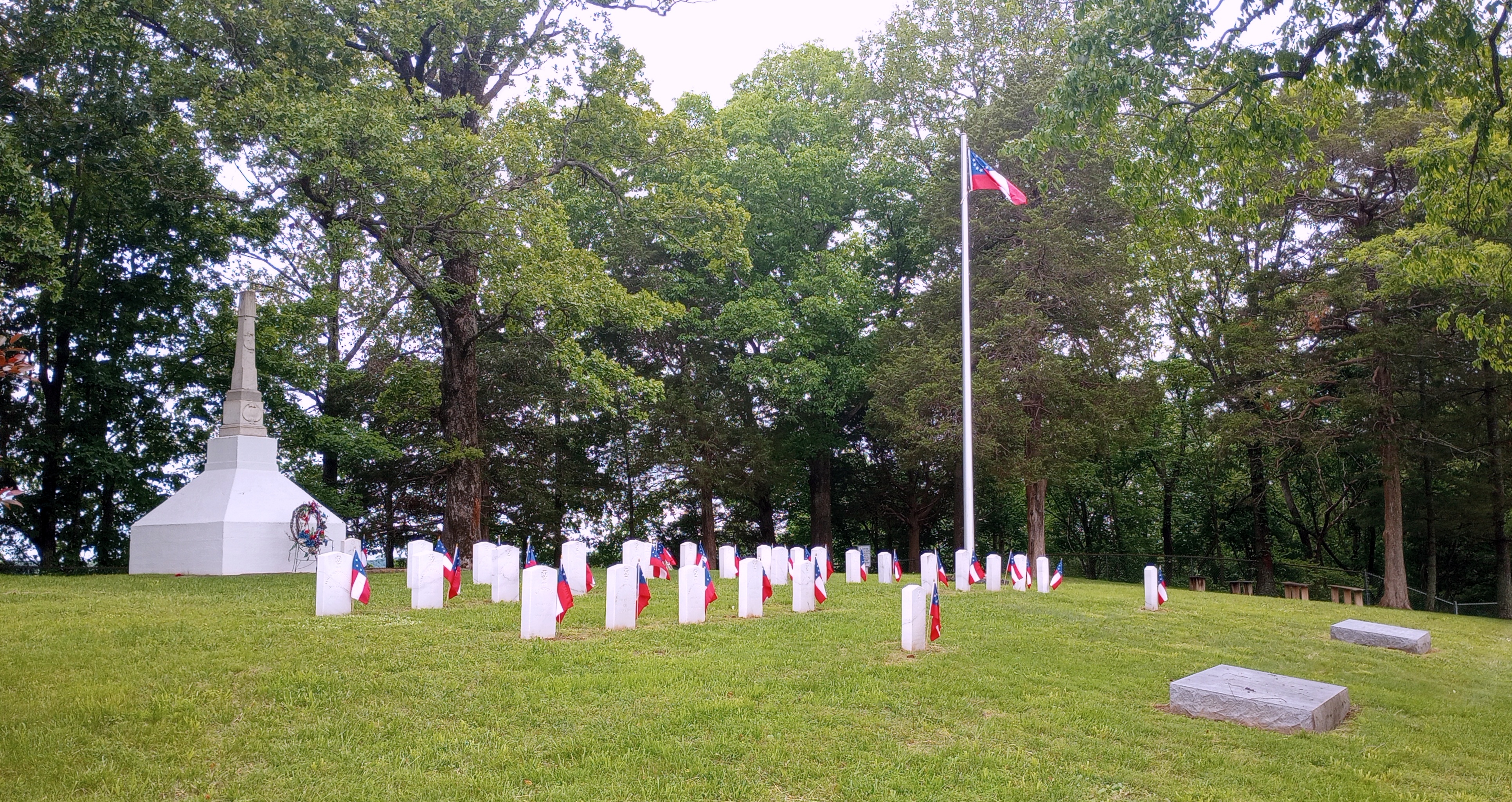
This one is near the campground, so let's call it Middlesboro.

I thought this was kind of ironic, the Cumberland Gap Tunnel. 

The Wilderness Road was the path that was used to cross the Appalachian Mountains back in the late 1700's to the early 1800's. The Cumberland Gap is a mountain pass on that road and had been used for a very long time by the local Indians and wildlife. The Appalachian Mountains were like an impenetrable wall stretching from New York down to Alabama. They were keeping the "white men" from going west. They were trapped between the Atlantic Ocean and the mountains. That is until the Cumberland Gap was discovered (actually re-discovered). There is a long history of events with many great stories in this area that affected American History. Today is my 4th and last day here and I went exploring on all 4 days. I'm a little bit tired and am looking at a long tow tomorrow. This blog post will have lots of pictures with captions, so I'll be brief as to the history.

Dr. Thomas Walker, while working for the Loyal Land Company back in 1750 was the first officially recognized white man to see the Cumberland Gap. He was surveying the property of Western Virginia (later to become the State of Kentucky in 1792). 

Daniel Boone was a hunter and outdoorsman. He would take long hunting trips to get furs and stuff from the wild and bring it back to the cities in the east. On one of his trips in 1769, along with 4 other men, he saw the Cumberland Gap. The Gap allowed him to easily (compared to going over the mountains) cross the mountains to get to the Kentucky area. 

When Boone returned, word spread throughout the east and people gathered up their belonging and headed to Kentucky, by going through the Gap. Boone took his family to Kentucky and established a fort/city, north of the Gap, and called it Boonesboro. Two of his sons died from Indian attacks while going through the Gap.  

Although he wasn't the first to travel the Gap, Boone's name became synonymous with it, freedom, exploring, free land for the taking, plentiful game, etc.  Between 1780 and 1810, about 300,000 people emigrated westward to Kentucky and beyond. That migration was about 6% of the entire American population at that time. Six percent of the current U.S. population would be about 20,000,000 people. Can you imagine that many people getting up and walking a couple hundred miles with everything you owned on your back or if you were lucky a pack animal?

Boone was a hero to many, but controversy followed him. Due to debts and land disputes, Boone again packed up his family in 1799 and headed west. Boone was 67 years of age at the time of the move. His plan was to leave America by crossing the Mississippi River near St. Louis and enter Spanish Territory. The Spanish welcomed Boone with big fanfare and gave him land and prestige. They did this because they knew that where-ever Boone went, people followed. They even appointed his to be a judge. But the joke was on Boone because in 1803, Spain gave control of the land to France who in turn sold it to the U.S. in the Louisiana Purchase. So, America caught up to Boone and it would be interesting to know his thoughts about that. My post about Boone Missouri home and burial site is covered in my old post located here >>>> https://www.blogger.com/blog/post/edit/1092960427378302566/459143345405690160

Boone died in 1820 at the age of 86. He may be buried in a grave along a small two-lane highway near the town of Marthasville, Missouri (about 50 miles west of St. Louis). I say "may be" buried there because the State of Kentucky says they exhumed him and re-buried him in Frankfort, Kentucky. The State of Missouri says they dug up the wrong guy. What is known for sure is that his wife, who preceded him in death, and he was buried next to, was exhumed by her family and returned to Frankfort, Kentucky. According to Kentucky, they are buried together. I like to think Boone would have preferred the burial site in Missouri which would have been nearer the frontier. When I visited his Missouri gravesite, I could picture him there looking to the west and watching the sunset. Some tales say, after he got the family settled down in Missouri, he went wandering and made it all the way to the Yellowstone area before returning. Maybe, maybe not. 

There were two main places I wanted to explore. The first was the local museum. It is now in my top 5, mainly due to the historian/director of the place. Very knowledgeable, informative and talkative. 

The other place to explore is a trip to the Pinnacle Overlook and Fort Lyons. It is a mountain with a nice road to the top with plenty of "kiss you a$$" curves and drop-offs. It's been a tourist attraction for several decades, maybe 10. 

One of the smaller "Kiss your a$$" curves

A view from near the top of Pinnacle. I think that's a natural lake in the distance. 


The north and south militarized the mountain by places cannons in several locations near the top.

This was from my first visit to Pinnacle. I was the only one there, probably because it was early and the weather was overcast. My second trip was more crowded with about 15 vehicles in the parking lot. 

They have very nice paths and the one to the overlook is wheelchair accessible. If you make the climb higher up to Fort Lyons, it is a much steeper climb and in my opinion wasn't worth the effort. 

A cicada on the handrail. They have been "chirping"/"singing" a lot at the campground and area. 

An uncomfortable bench on the trail coming down from Fort Lyons. That paint line is a state line. I think it was TN/VA

Getting close to the overlook. Nice paths, uh?

That's the overlook. This was from the overcast day.

One of the views.
Another view

I liked this one of the mountains in the overcast rather than on the clear day.

Time to jump up on the soapbox for a little bit. Manifest Destiny is something I learned about in school back in the 60's. The way it was taught was, America had no choice but to move our population westward. That we had a divinely ordained right and duty to expand westward across the continent. If anyone questioned it, those two words, "Manifest Destiny", ended all arguments. Of course, the westward expansion meant conquering and displacing the Indians, which we did. I don't have a problem with that since stronger civilizations always conquer weaker ones if they have something the stronger one wants. This was done by the Indian tribes as well. The best example is the Comanche Indians. They started out in Western Wyoming before migrating and taking land in the southwest and Texas. They conquered and displaced the Apache, Navajo and many others. It was and is a way of life among civilizations. But it all depends on how it's done, honorably or dishonorably. A lot of our displacement of the Indians was done dishonorably. But it was overlooked and passed off because it was "Manifest Destiny" and we just couldn't help ourselves (sarcasm). That is right but also wrong. Just like a lot of things in life, it falls into a grey area. One of the arguments that should have been used back then would have been, if it's Manifest Destiny, then what about expanding into Canada and Spanish Mexico. The reason we didn't expand into those area was because England and Spain were militarily powerful enough to stop us. Maybe we learned a little from that experience because after World War 2, we could have taken over several countries as the world's only superpower, but we didn't. Instead, we help rebuild them. In fact, we helped two of our enemies from that war to become economic powerhouses (Japan and Germany). I guess in a way, it all balances out in the long run. I'm sure the Indians don't look at it that way though. 

Making judgements on things that happened in the past must be weighed against the mores of their times. This is not a hard-fast rule either and has a lot of grey area. Oh well, it's something to think about. 

Tomorrow is moving day and I'll be heading east into northern North Carolina to a COE campground. I changed my route and increased my mileage by 80 miles and 45 minutes in order to stay mostly on Interstate and 4-lane highways. It will be about a 4 to 5 hour tow. I figure I'll be nice and tired but with it being easy towing, I should get a lot of good "thinking driving". 

Ya'll take care of each other. Maybe I'll Cya down the road. 


Wednesday, May 14, 2025

Surrender, Starlink and Serendipity

 Location: Smith Ridge Corps of Engineers Campground; Campbellsville, Kentucky (about halfway between Louisville and Boonesboro)

First the good news; The school, my granddaugter's archery team, finished 5th in 3D and 8th in Bullseye which qualified them for the National Championship in Myrtle Beach next month. Now the bad news; Each team must have a minimum of 10 archers and there weren't enough of our team that was willing to go to Myrtle Beach, South Carolina. Reasons were many such as prior commitments, expense, parents work, etc. Oh well, maybe next year. So, one way to look at it the team wasn't beaten, they simply surrendered. This changed my travel plan a little. I'll still be back in Louisiana on July 1st, but now I won't be staying in Myrtle Beach. I just finished canceling, modifying and adding campsites to my new route. Reservations are good all the way back.

First of two road pictures. Notice the contrasting landscape. For reference this somewhere in middle Kentucky.

This picture is 45 minutes later than the one above. Kind of surprising change uh?

This campground is like an old style one, with narrow and twisting roads, but it is peaceful and quiet. The campsites are roomy and not crowded. But, (there's always a "but" isn't there),,,, I have absolutely zero cell phone service. In fact, I couldn't pick up a Verizon signal in the nearest town of Campbellsville which is a college town with a population of 12,000. I asked several people, and they told me it has been like that forever. The cell phone companies just tell them it is a dead zone and they may build a new tower but never gets around to it. Most people around here are forced to pay high prices for DSL through their cable company. This sure seems like the poster child for the Democrat promise of rural broadband. Heck, the senior senator from this state was the Majority Member of the U.S. Senate. This just ain't right. But I anticipated stays like this and that's why I bought my Starlink. I have a nice view of the northern sky and the signal is great. I'm able to get online, make calls and text. Starlink saved the day.

It's a nice campground and I would return, but only with Starlink. That's it sitting on a mini tripod at the drivers side back corner of Liberty. 
This is the outlet from the lake. Very, very powerful feeling standing nearby. I took a video, but not posting it due to size.


This picture was taken from the same spot as the one above, just turn 180 degrees. Nice.

This is taken from the road on top of the dam. That concrete tower is the intake structure. That is where the water came from that resulted in the massive flow of water out the pipe in the above picture. I got lucky and the lake was very calm. 

I'm only here for 3 days and my only plans were to explore the dam on the Green River and check out the Corps visitors center. Bam, Serendipity happened. While at the visitor's center, I noticed an old log cabin. Come to find out it was an old house from the mid 1800's and it served as a Confederate field hospital after a local Civil War battle. I hadn't heard of the battle but had heard of the Confederate General. He was General Morgan and he led a raid of Confederate calvary from Tennessee to northwest Ohio. The raid didn't receive a lot of press because it was being done at the same time the South was losing at Gettysburg and Vicksburg. But the raid was interesting and worth reading up on it. The little skirmish around here happened in early July of 1863 when Morgan was headed to the Ohio River. He needed to cross the Green River first and the Union had a couple hundred soldiers dug in at the bridge. Morgan tried eight times but was turned back each time. The Union soldier were dug in real good. After the eighth time, Morgan said, "we can go around instead". It was a shame he didn't think of that at first because it would have save the lives of 36 southerners and 6 northerners. The 45 wounded Confederates were treated in the log cabin that was eventually relocated to the Corps Visitor's Center. You can still see the blood stains on the floor. 

There is also a nice 3 mile car tour that highlights the places during the battle. A Confederate cemetery is also located along the road. Many of the bodies buried there were recovered from burial trenches where the Union Army had put them. One of the placards at the cemetery mentioned an event where 4,000 people attended an event to place flowers on the graves. It was in early June of 1911, Confederate Decoration Day, which was the precursor to the modern-day Memorial Day. I stopped and paid my respects. I will always stop at any Veterans Cemetery. 

This is a one-lane bridge on the battlefield road tour. It seems as though they are trying to make it look old, but the structural steel members look almost brand new. 


The bridge crosses the Green River just a short piece downstream of the dam

The Confederate cemetery. The flag flying on the flagpole as well as the one on the gravestones is the First official National flad of the Confederate States of America. It was called the Stars and Bars, not the one you see now a days. That flag came later. 


There is a nice little walk around the Visitors center that takes you to the log cabin/field hospital. This is not the original location, that was near the point where the cemetery is located now. 

Tomorrow is moving day and I'll be headed to Daniel Boone country. It is a place that has been on my list of places to see for a while. 

Ya'll take care of each other. Maybe I'll Cya down the road.

Sunday, May 11, 2025

Archery Tournament

Location: Charlestown State Park; Charlestown, Indiana (on the Ohio River about 15 miles upstream from Louisville, Kentucky

When I left Louisiana six weeks ago on March 24, Louisville was my long range destination. It's taken me 13 campgrounds and 1,600 miles of towing to get here, but here I am. The reason for coming to Louisville was to attend my granddaughters' archery tournament. The competition was the Eastern National Championship in the National Archery in the Schools Program (NASP). Schools from the eastern states competed to see who would qualify to go to the National Championship in Myrtle Beach, South Carolina on June 5th through the 7th. My confidence level is high, so I already made reservations all the way to Myrtle Beach and then back to Louisiana. We're pretty sure her team qualified but we have to wait for official notice next week.

That's Olivia in the middle facing to the right. The position is referred to as "bows on toes" and everyone must be in this position before the official grant permission to shoot. 
There are two separate competitions. This one is called 3D. There are 6 different animals. Each contestant shoots 5 arrows at each animal before moving on to the next one. The other competition is the standard Bullseye target. 
The Kentucky Exposition Center is massive. This picture is just a small portion of the vendors area. Very good venue.
I had to take a picture of Olivia and Nate to send to my X-wife who couldn't make the trip. Just a little bit of rubbing it in. LOL
Here's a selfie of me and Nate while we wait for Olivia to shoot. The headphones are connected to a tablet so he can play some educational games. 

I've stayed at this state park back in July of 2023. It was a great day of exploring with multiple serendipitous things occurring. I purposely decided not to back track and try to repeat that exploration. I have done that before in other places and sometimes it can taint the good memories turning them a darker shade. Here is a link to that old post after re-reading it, it brought back some warm, good memories and vibes. That is the beauty of keeping a blog of my travels. It is a means of transporting my mind and soul back in time. It's OK, I'm only half crazy. The big question is am I going downhill or uphill to get to that half-way point? Oh well, here's the link >>>> https://gozatravels.blogspot.com/2023/07/serendipity-day-top-10-museum.html


This is the "Blue Bridge" crossing the Ohio River going from Kentucky to Indiana. The U.S. Supreme Court ruled the state line between those states is the northern low water mark of the Ohio River back in 17 or 1800's. So technically, Kentucky owns the river, but not really.


Obligatory road picture. This is Northern Kentucky or Southern Indiana


Same goes for this picture, northern Kentucky or souther Indiana. I'm leaning more so to Indiana.

This road is within the State Park and leads to the Ohio River. I remember this one from last time. Neat looking road.
The State Park has a nice overlook with a pretty comfortable bench. A place to reflect on your life and try to see your future as you look on the peaceful Ohio River. 

I chose poorly on my campsite. I used three boards (1X8's) and was till about a 1/4 bubble out of level. But that's OK, minor problem in the big picture. That's my Starlink, on a tripod, at the front corner of Liberty. I'm still really satisfied with it.

Tomorrow is moving day and I'll be headed down into the middle part of Kentucky to what looks to be a nice COE campground

Ya'll take care of each other. Maybe I'll Cya down the road.  


Tuesday, May 6, 2025

Just Driving Around Pictures

 Location: Laural Branch Corps of Engineers Campground; on the banks of Rough River Lake which is about an hour or so southwest of Louisville, Kentucky

The tow to get here was almost three hours on some narrow state highways. The type of narrow-ness that if you "hook" a wheel off the edge of the road it will put you in the ditch quick. I've been pressing my luck on my choice of roads during the last few weeks. I still believe in what I said for years, "tow on the interstates and explore on the blue highways". The main reason for that is if something happens while towing there would be a shoulder to use to get off the road. Some of these roads I've towed on lately have been less than 11 feet wide. I can tell the width because they didn't have an edge line. Edge lines are used on roads with 11 foot wide lanes or wider. Oh well, I guess I'll continue to push my luck some more because after Louisville, there aren't a lot of Interstates or four-lane highways on my planned route. Fingers crossed. This post is going to be overloaded with road pictures. All are from central to northern Kentucky.

You can tell the kind of weather I was towing in. Popcorn showers (rain popping up here and there). None were real heavy.


This is what I usually think of when I think of rural Kentucky. The only thing missing was horse in the fields.
This was a nice road with shoulders. You can see a little of the hills.
I took this one because of the cow looking at me. I know it wasn't a Texas Longhorn, but it did have long horns.
The last country road shot. In future posts, if I forget to satisfy my promise to post road shots, remember I overloaded them in this post.

This campground was a replacement. I received an email from Recreation.com, the federal campground reservation website, that my reservation at Axtel Campground was canceled due to flooding. I was lucky to find a site at this campground which was only a few miles away, on the same lake, but on higher ground. It has three loops, and one is flooded but the other two are open. I appreciate the Corps not closing it because I'm sure they were tempted to do so. It's a nice campground in the middle of nowhere. The sites are level, paved and mostly shaded. My cell signal is weak but reliable. I set up Starlink for the first time in a while. I found an opening in the trees and hoped it would work. It's not a blazingly high speed but very usable. I put the receiver on my tripod for the first time. It worked well but I need to find a weight to hang under it, just in case.

I hitched up in the rain and set up camp in the rain. I didn't mind it at all. It was the first time I've done in a couple of years and change is always a good thing. How boring would it be to hitch and tow in pretty weather all the time?
I'm guessing people canceled their reservations due to the rain because the campground was only about half filled. That is Rough River Lake in the background. That would have been a good campsite.
This is the loop in the campground that was closed due to flooding. Notice the trees standing in water. Those kinds of trees are not suppose to do that. 
That's my Starlink on the small tripod at the back corner of Liberty. Starlinks need to point north and mostly lay flat. I'm still very satisfied with mine.
I took this picture for future documentation. This is pointed up from the Starlink receiver. That hole in the tree coverage is what is allowing the satellite connection. I'm satisfied that I could find enough opening to connect in most campgrounds.

I drove around the area on day 2 of 3 with nothing specific in mind to explore. It was a nice drive and I ended up in a small town where I filled Freedom up with gas and got a special lunch at Dairy Queen. For $7.00 I got a cheeseburger, fries, drink and sundae. Good deal, Lucille. While sitting in DQ eating my good deal, I thought hmmmmm,,,, how many times have I ate a meal like this in small town and not know a living soul for several hundred miles around? My second thought was there had been times in the past where it was over a thousand miles so I should be happy. I wasn't happy but I also wasn't sad. Melancholy probably isn't correct either. I need to think on it some more.

Two of my favorite places, Dairy Queen and Walmart. I didn't go in Walmart but enjoyed DQ. All of the workers in the DQ were much older than usual which may have accounted for the above average service and quality of food. Good job, ya'll.

Tomorrow is moving day and I'll be going to an Indiana State Park that I've been to before. I'll use it to be close enough to Louisville, Kentucky to attend my granddaughter's archery tournament on Saturday. It is the Eastern National Finals. It will be a long day on Saturday but I'm looking forward to it. 

I've seen more and more of these large flags on this trip. Much more than on past trips. Patriotism is flourishing in the country. 

Ya'll take care of each other. Maybe I'll Cya down the road.  

Saturday, May 3, 2025

Having to Walk to a Cemetery

 Cedar Creek Corps of Engineers Campground; Mount Juliet, Tennessee (just a little east of Nashville on the banks of the Cumberland River)

This is the second time I've received a call/message from a campground host telling me my site is ready. I was doing some shopping at Walmart, and doing it slowly, because I wanted to kill some time so as to not arrive too early at the campground. My phone rang and the campground host said my site was ready for whatever time I showed up. I liked that. It's a benefit to the hosts as well, because they know if and when the campers will arrive. This campground is a nice little one that seems to be maintained really nice. The hosts are in the booth for most of the day while others are cruising the campground in a golf cart. Everyone is doing their job just right. That is rare now a days since most booths at a lot of the COE's aren't manned at any time.

Required travel picture. This is from north central Tennessee

My campsite. The view out my back window is the entrance to the campground with the host booth. It has been a lot of people watching. Fun and interesting.

That is the lake next to the campground. It was formed by daming the Cumberland River. You can see all of the drift wood that washed up during the last flood. 

I've been to this area before but not at this campground. It was back in April of 2016 when I came here to visit The Hermitage, President Andrew Jackson's home/museum. I remember the exploration being somewhat of a disappointment but wasn't sure if that disappointment was a result of my disappointment in the man himself or his home. You can read about that exploration here >>>https://gozatravels.blogspot.com/2016/04/andrew-jackson-and-hermitage.html

There are a couple of reason why I don't like Andrew Jackson.  He took office in 1829 which was the same year the State of Georgia decided to take 9,000,000 acres of land away from the Cherokee Indians because some gold was found on it. Their perverted logic was "what are the Indians going to do with the gold anyhow". The Cherokee, trying to prove to the whites that they could act white, sued Georgia saying the treaty they had with the U.S. guaranteed the land was theirs. That suit went all the way to the U.S. Supreme Court where the court sided with the Cherokee and against Georgia. Georgia decided to ignore the court ruling. In a situation like that, the head of the Executive Branch of government, President Jackson, was expected to uphold the Court ruling by forcing Geogia to comply even if it required military action. Instead, Jackson also ignored the Supreme Court and is famous for saying, "John Marshal (the chief justice) has made his decision, now let him enforce it". A true constitutional crisis, not a fake one like you hear about now-a-days. The Cherokee were left to hang out to dry, abandoned. They were forced to sign a new treaty where they traded their lands in the east for land in what would become Oklahoma. They felt they had no choice. Three years later, Georgia thought they were relocating too slowly so they asked for Federal help. Jackson sent the Army to force them to move quickly thus creating the famous Trail of Tears where 1/4 of the Indians who began it, died along the way. Jackson, as President, was responsible for a shameful act and doesn't deserve respect. 

This time around, I learned of a Confederate Cemetery on the grounds of the Hermitage. I didn't know about that on my original visit. I wasn't interested in exploring the Hermitage again but was wanting to show my respect for the "fallen" soldiers. Surprise, surprise, the cemetery is on the Hermitage property and a person has to buy a "grounds ticket" just to go see the cemetery. By the way, that ticket costs $21.00. I wasn't going to pay their extortion but I was going to visit the cemetery, even if I had to jump crawl over the fence to get in. So, what does a person do in a situation like this? Google Earth is what I did. I called it up to see exactly where the cemetery was located and a way to get to it. The plan was to park Freedom in the CVS parking lot, cross a 5-lane highway and 2 bike lanes to reach a sidewalk. A little less than 1/2 mile later, I was standing within spitting distance of the nearest headstone with only a split rail fence between me and the cemetery. I looked both ways to make sure no cops were watching and decided trespassing charges would not be in my future on that day. Maybe some other day but definitely not on that day. My secondary choice was to take some pictures from the sidewalk and quietly paid my respects then walked back to Freedom with my head held high knowing positively that I had just "stuck it to the man". 

The cemetery opened in 1892 by the Tennessee Confederate Soldiers Home. The home stayed open for 41 years and closed in 1933 when the 6 vets still remaining were transfered to the Girls Infirmary at the Tennessee Industrial School. The last vet passed away in 1941. There are 487 graves in the cemetery. Most were poor farmers fighting against what they perceived as an invasion from the Union Army. 

I was surprised the stones only had numbers. They do maintain an accounting of "names to numbers". I was happy to see a Confederate cemetery. It is only the third that I've seen in all my travels. There is one in Keachi, Louisiana and another one in Rock Island, Illinois. 


At least the "crazies" haven't trashed this memorial like they have so many other confederate sites. Those sites they trashed were more like headstones since the confederates were usually buried in mass graves and lost to time if they didn't win the battle. 

Tomorrow is moving day and I'll be heading north into Kentucky for another COE campground stay. 

Ya'll take care of each other. Maybe I'll Cya down the road.