Tuesday, April 14, 2015

The Remarkable Sacagawea, a Dog and Bonneville Dam

Location: Ainsworth State Park (El. 100 ft); Cascades Lock, Oregon

(click pictures to enlarge)
(all pictures taken with Nokia Lumia 929 Cell Phone)

It has been raining on and off with wintry mix thrown in just to keep things interesting. The cold front passed through in the early afternoon and the temperature should drop to the lower 40's/upper 30's tonight. Tomorrow is moving day with hopes of getting to a dryer and warmer climate. The move will be to a town called Redmond, Oregon located between the Cascade Mountains and the high desert of the Central Oregon. The weather forecast calls for a low in the mid 20's there on Wednesday night but then much warmer for days afterwards. I will be there for 3 or 4 days before heading farther south. I'm still hoping to be able to see Crater Lake before leaving Oregon.

I was able to see a few things in between showers late yesterday evening and then again today when I went into town to gas up for tomorrows trip. There are a few nice statues in the Marine Park located in Cascades Lock. The first one is of a cougar entitled "Silent Descent".

Silent Descent

The other statue is of Sacagawea and Seaman. I have seen several representations of Sacagawea at different towns on my trips but the one at this park is the best so far. 

Sacagawea was born the daughter of a Shoshone Chief but was kidnapped when she was about 10 years old by the rival Indian tribe of Hidatsa. The Shosone lived in the area of the Bitter Root Mountains in what is now Idaho and the Hidatsa lived in the upper Missouri River area of present day North Dakota/South Dakota. After being kidnapped she was later sold to a French Canadian trapper who she ended up marrying. His name was Toussaint Charbonneau. Sacagawea was in her late teens when she gave birth to her son John-Baptiste. He was born about the same time that Lewis and Clark and their Corps of Discovery was passing through the Hidatsa territory and their friendly neighbors the Mandans. They were in need of an interpreter to accompany them on their trip to the west coast and wanted to hire Charbonneau. Charbonneau agreed but stipulated that his wife, Sacagawea, and their son would also go along. John-Baptiste was 8 weeks old when the group departed for parts unknown and was carried on the back of Sacagawea in a cradle board. The group followed the Missouri River upstream until they reached its headwaters near the Bitter Root Mountains. It was there they sought out the Shoshone tribe to negotiate for horses that could be used to cross the mountains so they could reach the headwaters of the Columbia River which would carry them to the coast. 

It was during the Shonshone negotiations that a strange coincidence occurred. Sacagawea was part of the negotiations as an interpreter. It was there that she recognized her brother who was now the Chief of the Shonshone. She could have stayed with the Shonshone but she didn't, she continued on with the party as they crossed the mountains and went to the Pacific Ocean. 

Sacagawea and Charbonneau stayed with Lewis and Clark until they reached the Hidatsa/Mandan villages on their return trip. Both Lewis and Clark said Sacagawea was invaluable to trip. Six years after the trip she gave birth to a daughter named Lissette. About a year after her birth it is thought that Sacagawea died of some disease. It is unclear what actually happened to her and some people believe she lived to a ripe old age. What is known is that her son John-Baptiste and Lissette were sent to St. Louis to be raised by Clark. He had taken a shine to John-Baptiste during the trip and offered to raise him but was turned down by Sacagawea at that time. Something changed her mind after Lissette was born. Some people believe she became sick and knew that the kids would have a better life with Clark and sent them to him. Lissette died as a child not long after arriving in St. Louis. John-Baptiste became highly educated and even visited the capitols of Europe. 

Sacagawea with John-Baptiste on her back. The dog alongside her is Seaman, a Newfoundland Dog. Lewis bought it in Pennsylvania for $20.00 and he made the entire trips as well.
 The nearest town is Cascades Lock about 8 miles to the west. Cascades Lock got its name from the navigation lock built to by-pass the Cascade Rapids. Remember the post from a couple days ago about the Bridge of the Gods? The dirt one created by the landslide, not the modern day one. Well, when the dam that was created by the landslide washed away, what was left behind was a series of whitewater rapids with large boulders scattered everywhere. They were impassable by boat which required river traffic to portage around the rapids. This was very time consuming because everything had to be unloaded from the boat, carried around the rapids then reloaded on the boat. To solve this problem, a lock was built in 1896 across the land near where the portage took place. This allowed boats to enter the lock and be lifted or lowered before exiting the locks on the other side of the rapids. A town grew up around the locks and for the lack of imagination, they named the town, Cascades Lock. The town and the old lock is still there, although not in use anymore. 
From the walking bridge across the Cascade Lock looking downstream. The bridge in the distance is the Bridge of the Gods.

Looking upstream from the walking bridge. Notice the platform and net used to catch Salmon. 
The construction of the Bonneville Lock and Dam in 1938 eliminated the need for the Cascade Lock by submerging the rapids under the water impounded by the dam. Bonneville was the first of many hydroelectric dams with navigation locks on the Columbia River. It was a very big deal in these parts since the Great Depression hit this area hard and the unemployment rate skyrocketed. The lock that was built as part of the dam was the largest single lift lock in the world at the time. It has a 60 foot vertical capacity. The other unusual thing about this dam is that it incorporated "fish ladders" to allow fish, such as Salmon, to go upstream to spawn.

This is the number 1 powerhouse that was originally built with the dam.

The downsteam gate of the lock. Notice what appears to be the emergency closure blocks to the right.

One of the powerhouses

View from the top of the visitors center. To the left is the dam with gates open, the center is impeller from one of the powerhouses. 

The fish ladder

You can see the fish as they pass through the fish ladder. They are counted and sorted by fish type. I only saw two pass while I was there but was not quick enough to get a picture.

A nice bench to view the river downstream of the dam


Ya'll take care of each other. I'll Cya down the road. 

Monday, April 13, 2015

Driving around the Columbia River area

Location: Ainsworth State Park (El. 100 ft); Cascade Locks, Oregon

(click pictures to enlarge)
(all pictures, except one, taken with Nokia Lumia 929 Cell Phone)

It's raining again today, but didn't start until the afternoon. So far, it has only been gentle rains so they aren't too bad. It seems to keep the air crisp and clean. 

Although I-84 is now the major highway that parallels the Columbia River, there are long stretches of old U.S. 30 that are still maintained and open to the public. This highway was originally built about 100 years ago as a county road before being added to the U.S. Highway system in the mid 1920's. It is a curvy and hilly road that hugs the edges of mountains and shear bluffs along the Columbia River. The building of this road during that time was a major achievement, equal to many other Engineering feats of that time. At the top of a headland of basalt, there is a promontory where the Assistant Highway Engineer for the Colombia River Highway Project, Mr. Samuel Lancaster, pushed the higher-ups to build something special. He envisioned a stop where people could see the wondrous views of the Columbia River and rest a while before continuing on their journey. The place that was built is still standing and still serving the original purpose almost 100 years later. The place is called the Vista House.
Vista House as seen from I-84

You can see part of the highway that curves in front of Vista House. This view is still from I-84.

Vista House

The view looking up-river from Vista House

The view looking down-river from Vista House.

The Columbia River with clouds


Mount Hood is the highest mountain in Oregon. It is one of the many Strato-Volcanoes in the Northwest. It is supposedly caused by a subduction zone which is part of the Continental Drift Theory. These pictures were taken from an overlook on the outskirts of Portland. I will probably be able to see the mountain for most of the time I'm in Oregon. 


Mount Hood

Mount Hood

Mount Hood

Mount Hood

Ya'll take care of each other. I'll Cya down the road. 

Saturday, April 11, 2015

One Year on the Road Today

Location: Ainsworth State Park (El. 100 ft); Cascade Locks, Oregon

This post is going to be overloaded with "I's" because it is more personal than most of my other postings. There are not any pictures because I can't pick just a few from the many thousand pictures that I have taken, so this is fair warning.

A year ago tomorrow marks one year since I pulled out of the parking lot of my office and drove east into a new life. I bought my first RV about 6 months before that and had been living in it while getting used to its systems. I also bought a new truck to tow the RV. I order several things that I thought I would need. I was correct on the need for several of the items and wrong on a few. The most important things I was correct on were my Cell Phone, Ceramic Heaters, Tire Pressure Monitoring System, Power Mirrors on Freedom, a Lazy Boy Recliner and Keurig Coffee Pot. I had read a few blogs about full-time RV'ers and the life they were living. I also knew that as with most things, they were probably sugar-coating a lot of it, but that was OK with me, I would find out for myself. 

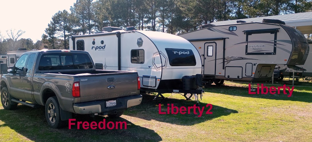
I named my RV, "Liberty" because liberty means 'using your free will to do as you please'. That is why the Navy calls the time when you are away from the ship/base as being "on liberty", meaning you are able to use your own free will to decide what to do instead of being directed by superiors. To me, retirement equals "being on liberty". My truck is named "Freedom" because it gives me the freedom to go anywhere I want to go. 

I travel in Freedom but sleep in the comfort of Liberty.

I retired at the age of 58. In fact, I hit the road 2 days after my 58th birthday. There had been several of my friends that had passed away at an early age before they could enjoy any of their retirement. I loved my job and I think I was pretty good at it (my x-co-workers may disagree) but I knew if I didn't retire and do something new, then I would stay working until the medics hauled me away from my office. It may sound strange, but there was no in between for me, either all work or all retirement. My plan going into this life was to see and do as many new things as I could before I either got bored with it or I physically couldn't do it anymore. That is why I travel as quickly as I do. I am proud of this country and the freedoms I have to do what I want, whenever I want. 

There is always a lot of talk among full-time RV'ers about needing to slow down on their travels and spend more time in places. They say it is to "really get to know a place". I understand that train of thought, I just don't think it fits in with the way I want to do my traveling. I may change my mind in the future but right now, my general traveling philosophy is like this: I will find 1 or 2 things to see or do in an area, do them, then move on to the next place. I figure number 3 and 4 on the list of things to do and see in the current area is not as good as number 1 or 2 in the new area. Now that isn't always a hard fast rule because there have been times when I stayed longer in places. An example of that is where I am at now. I came here to tour the Bonneville Dam, see some waterfalls and the Columbia River Gorge. I could do all of that in just a few days but since I found a nice State Park with cheap rates I decided to stay for 6 days. 

My travel stats for the year are:
25,793 ---- total miles traveled
13,165 ---- miles towing Liberty
12,628 ---- miles exploring in Freedom
140 -------  average miles between campgrounds
134 -------  average miles exploring an area
10.4 ------  overall average MPG for towing/exploring

On average, I move campgrounds every 3.9 days

I've been in 32 states and stayed in 94 different campgrounds of which 48 were state parks. 

I like state parks because they are usually just basic campgrounds without all the amenities that people with kids are needing or local people who come to camp. I use the campground as a base camp while I explore the area. I rarely put my lawn chairs or awning out and have never used my BBQ grill since I've been traveling because I don't want to have clean it all the time. When exploring I usually leave the campsite by mid morning and return late in the afternoon. I travel solo in my adventures. I have met a few people along the way but they are few and far between. I guess if I stayed longer in places I would meet more people, but with me moving every 3 to 4 days, and rarely in the campgound, there just isn't much opportunity to meet.   

During the year I've seen many Civil War sites, including Appomattox where it ended. I've seen both the Atlantic and Pacific Oceans, and all five Great Lakes. I saw Niagara Falls and the finger lakes of New York state. I toured the sites of Washington D.C. by riding the train into the city (which some people said I was crazy to do alone). I saw the memorials to the past Presidents and most importantly I saw the memorials to the real heroes, the war memorials. Especially poignant for me was the Vietnam Memorial, "The Wall". I saw the Garden of Stones (Arlington Cemetery) and watched in reverence the changing of the guard at the Tomb of the Unknowns. In a small town in Virginia, I visited the official D-Day Memorial, located there because it had the highest concentration of men, per capita, who died on D-Day. I saw the field in Pennsylvania where Flight 93 crashed on 9-11. No telling how many people those passengers saved by giving their lives to bring that plane down. I saw the new tower that took the place of the Twin Towers. I saw Lady Liberty with her torch held high and Ellis Island where so many people became Americans. 

I rode boats on the Erie Canal in New York state,,,,, in the Atlantic Ocean around Acadia National Park in Maine,,,,, on Lake Superior to see the Pictured Rocks,,,,, thru the Soo Locks at Sault St. Marie, Michigan,,,,,, to Mackinaw Island in Lake Huron to see the Grand Hotel,,,,,, on the St. Clair River around Port Huron, Michigan. I saw where the Mississippi River begins it's trip to the Gulf of Mexico and I stood at the junction where the Missouri River joins the Mississippi River. It is a powerful feeling standing on that little peninsula with a mighty river flowing on both side of you. I camped on the banks of the Mississippi and watched as tow boat/barges passed by as if they were in a parade. I camped in places were Lewis and Clark camped. I saw giant boulders that had been moved during the last Ice Age and deposited in the middle of fields. I saw the Giant Sequoia and Coastal Redwood trees. Some more than 2,000 years old.  

I flew over Hoover Dam and the Grand Canyon. I've walked trails in the deserts, woods, lake shores and badlands. I've been to the Mexican and the Canadian borders, but never crossed them. I saw the shockingly blue waters of Lake Huron and a storm blowing in off Lake Michigan. 

I've crossed the Smokies, the Allegheny, the Adirondacks, the Green, the Rockies, the Cascades and many other mountains.


I've seen and sat in a lot of "thinking" and "resting" benches in some of the most spectacular places. That may be one of the most enjoyable things I do is finding and trying those benches.

These are just a few of the thoughts that come to mind about the past year. There has been so many new things to see, they sometimes blend together. 

Most importantly, I visited several old home places that I lived as a child. Memories flooded back during those visits.

I am happy with the decision I made to hit the road. I miss seeing my family on a regular basis, but for now, seeing them around Thanksgiving and Christmas will have to suffice.

I am glad I started this blog. It is a great way for me to document what I've done and the places I've seen. The grandchildren will be able to read about what the crazy ole man did on the road.

After proof-reading this post, it is a bit rambling but I guess that is to be expected when trying to bring to mind a years worth of traveling. 

If I missed anything or if ya'll have any questions, please don't hesitate to post the question in the comments section. I answer all comments. If you don't want to post it publicly, my email should be somewhere on the blog. If not, send it to ,,,, darrell_g42@hotmail.com  

If you send an email and don't hear back from me, then post a comment to the blog, because sometimes my email spam filter catches emails that it shouldn't.

Ya'll take care of each other. I'll Cya down the road.


Friday, April 10, 2015

Moving Day to Ainsworth State Park, Goodbye Pacific, Hello Waterfalls

Location: Ainsworth State Park (el. 100 ft); Cascade Locks, Oregon

(click pictures to enlarge)
(all pictures taken with Nokia Lumia 929 Cell Phone)

I said goodbye to the Pacific Ocean on Wednesday evening while hoping for another good sunset. The sunset was nothing special but the weather was nice. I'm not sure when or if I'll see the Pacific again but it is very close to the best of all the Oceans, Gulfs, Inland Lakes, Fjords and Seas that I've seen in my lifetime. It is very peaceful to see it, but I didn't see any storms though. I will miss it.
The tide time was approaching low tide with the waves slowly rolling in

This was the sunset. Notice the ship on the horizon. It pulled out of the river just before I got to this vantage point. 

While I was saying goodbye, I noticed the remnants of the old railroad that was used to build the jetty. Those piles sticking out of the rocks supported the railroad that transported and deposited the rocks for the jetty.

On the way back to the campground, I saw the rest of the railroad bridge that went across the low marshy area. I checked it out on Google Earth and sure enough, it lines up with the Jetty. Nice.

I pulled out of Fort Stevens State Park about 10:30. The temperature was a little chilly at 49 degrees, but it kept the mosquitoes from flying around. Although at times there are lots of big mosquitoes, I was never bitten by one. I'm not sure if they just don't like Southern meat or if they weren't hungry.

The trip was only about 130 miles which is the kind of distance I like since I don't have to fuel up with Liberty in tow until the distance gets to about 220 miles. About half of it was on 2-lane U.S. highways and the other half was on Interstate. It was a nice haul with some good change in scenery. I like being able to change from ocean views to mountain views all in the same day. That is one of the good things about this lifestyle of moving around is being able to change landscapes simply by moving to another campground. All the while, sleeping in the same bed. :)

The new campsite at Ainsworth State Park. The site took leveling blocks, 3 high, to get level side to side. I have only had to use that many one other time.


The view of Liberty as I was coming back yesterday evening.

 After getting set up I went about 9 miles north to the town of Cascade Locks to find something to eat. I have gotten to where I don't eat on moving days until after I get to the new campground and get set up. I ate at a place called Char Burger. The burger was very good, of course I was very hungry which means everything tastes good. I also tried a cup of their homemade chili which wasn't too good. The really good part was the biscuit they gave with the chili, it was really good. The restaurant has a gift shop attached to it which sells fudge and cookies. I bought a little fudge which was pretty good too.

Next to the burger place is the Bridge of the Gods. I saw the name as I approached the town and thought that was a very pretentious name for a bridge. The bridge is a canterlever thru truss bridge built in the late 1920's and spans the Columbia River. The State of Washington is on the other side. The interesting thing is it is privately owned. The current owner is the Port of Cascade Locks who charges $1.00 per car in each direction. None of those facts make it extra special enough to warrant such a name as Bridge of the Gods. 

After doing some checking, the bridge was named in honor of an event that occurred near that location more than 500 years ago. Sometime around the year 1500 (the actual time is in dispute), a giant landslide came down the mountains and completely blocked the Columbia River. This earthen dam allowed the Indians to cross the river by walking across the dam. The Indians believed the dam was created for them by their Great Spirit and their oral history called it the Bridge of the Gods. Eventually the dam washed away which created the Cascade Rapids which Lewis and Clark saw on their trip on the river. 
Bridge of the Gods crossing the Columbia River at Cascade Locks, Oregon

After eating I still had time to find a couple waterfalls. 
Part of Historic Route U.S. 30

Horsetail Falls

Multnomah Falls


That is the first video I have tried to post to the blog. I hope it works out.


I will be in this campground for 6 days. I think there is enough to see around here along with a relaxation day or two. :)


Ya'll take care of each other. I'll Cya down the road.


Wednesday, April 8, 2015

Astoria Column and Fort Clatsop

Location: Fort Stevens State Park (el. 25 ft); Hammond, Oregon

(click pictures to enlarge)
(all pictures taken with Nokia Lumia 929 Cell Phone)

Yesterday was the last day for a lot of exploration. I visited the Astoria Column. It is a 125 foot high concrete column built on the top of a high hill with images of famous events from this area wrapped around its outside. It resembles Trajans Column in Rome, Italy. I saw Trajans Column back in the 70's, and although it is 2,000 years older, the carved images on it are much more impressive. The Astoria Column is hollow with a spiral staircase going to an observation platform at the top. Think of it as a big concrete pipe standing on its end. There are 164 steps inside. Fortunately, there were a few landing platforms where I could stop and think, meet people, count my money, wind my watch, catch my breath. Lots of people were stopping because of getting dizzy after climbing so many spiral stairs. Once you get to the top, the view is very good and I'm guessing it's close to a 35 to 40 miles view in all directions with the mountains at an even greater distance.
Astoria Column. You enter through the door at the base

An example of the scenes depicted around the perimeter of the column.

A view of the Columbia River. Those ocean going ships look to be the same ones that I took a picture of a couple of days ago. Must be a long waiting line. 

Astoria sits on a peninsula with the Columbia River to the right, Youngs Bay on the left and the Pacific Ocean in the distant middle. The bridge on the right goes to Washington State. I crossed it and posted about it the other day. The bridge on the left goes to the coast and my campground. 

This is looking up Youngs Bay to the rivers that feed it. At low tide, lots of the bay is a "mud flat".

I found this bench next to the gift shop. There are too many people around for much deep thinking, so it is more for resting and looking. 
The "Streets of Astoria" leading downhill after leaving the column. Low gear all the way.

On the way back to the campground, I stopped at Fort Clatsop. It is the camp that Lewis and Clark built to make it through the winter before returning east. I don't know if I'm getting jaded to some of this stuff, but the camp only slightly interested me. Maybe it was because I read so much about it before seeing it. Either way, it was worth seeing. Notice in the picture the moss growing on the roof of the fort. That happens a lot around here. It is constant proof that the "rolling stone gathers no moss". But around here, that stone doesn't have to stop look before the moss starts growing on it. I'll be glad to get Liberty out in the sunlight and hopefully the next campsite is more in the open. Everything stays damp under these trees. 
Replica of Fort Clatsop, named after the local Indian tribe.

This is a copy of Clark's map from 1810. The detail is remarkable. He was an excellent mapmaker and navigator.

Benches cut from a single log. I was surprised at how comfortable they were to sit.

The moss beginning to cover the roof of the fort. 

Today is prep day to move tomorrow. I'll be moving about 30 miles to the east of Portland along the Columbia River. Tonight will be the last time I see the Pacific Ocean for a while. I'll miss it.


Ya'll take care of each other. I'll Cya down the road.

Tuesday, April 7, 2015

Cape Disappointment, a Museum and a Sunset

Location: Fort Stevens State Park (el. 25 ft); Hammond, Oregon

(click pictures to enlarge)
(all pictures taken with Nokia Lumia 929 Cell Phone)

It's been raining on and off since I've been here. Most of the time it is only a light rain and lasts maybe 30 minutes with a few hours of drying time between showers. The daytime highs have been in the lower to mid 50's with nighttime lows in lower 40's. There is an occasional breeze, but so far nothing that I would call "windy". I'm told this is normal for this area and time of year. The Oregonians are used to it and most of them wear a rain jacket all day long for warmth and rain protection. These are some hearty people around here. Last night at sundown, there were people walking in the surf barefooted and wearing short pants while the temperature was 49 degrees and a gusty breeze. I know what the temperature was because I was sitting in the warmth of Freedom and seeing the thermometer. As for me, I've been wearing a long sleeve shirt with t-shirt and a wind breaker, when needed. I have a heavier coat in Freedom but haven't needed it so far. 

I really like the Oregon Pacific Coast. I haven't experienced any of its bad storms yet and it looks like I'll be moving on before one hits this area. I will not be following the coast into Washington state. In fact, I'm not sure if I'll even camp in that state. Thursday is moving day and I'll be headed inland from here and plan to follow the Columbia River upstream for a while. I want to see the River Gorge area, Bonneville Dam and some waterfalls. After that, I'm not sure which direction I'll head and the weather will probably be the deciding factor again.

I crossed the Columbia River yesterday to visit the Cape Disappointment area. Cape Disappointment is the headland area located in the extreme south west corner of Washington state where the Columbia River empties into the Pacific Ocean. 
The Columbia River Bridge. It is so high because ocean going ships pass beneath it. The bridge is being painted so one lane is closed for parts of the bridge.

Once you leave the truss part of the bridge you still have a long way to go before reaching the other side. The river is almost 4 miles wide at this point.

There are at least two stories about how the cape got its name. The first story is that the British Captain John Meares was coming south along the Washington coast in 1788. He turned around when he saw the headland in the distance and returned to the north. Had he continued on just a little farther, he would have been the one who discovered the Columbia River, thus he was "disappointed". Instead, the honor of discovering the river goes to the American Captain Robert Gray who found the river 4 years later in 1792. Captain Gray successfully entered the river and named it after his ship. (I'm betting he was a single man and if not, his wife was probably PO'ed it wasn't named after her).

The second story is that when Lewis and Clark's Corps of Discovery reached the cape in 1805, they were "disappointed" about no ships being in the area. They had hoped to find a ship that they could get passage on to sail back to the east coast so as to avoid having to cross the Rocky Mountains again. 

The view from near the top of the Cape was great. The pictures don't capture the true beauty of the view. 
Nice view looking north. That would have been in the area where Captain Meares turned around and headed back north.

Looking south. Just around that point is the opening to the Columbia River.

Wouldn't you know it. There was a "thinking bench" with a nice view of the Pacific. It was a comfortable one too.
After crossing the river back to the Oregon side I went to the Columbia River Maritime Museum. Overall it was a decent museum but since I've seen a couple of these type of museums before, it was just so-so for me. Unlike women, once you've seen one maritime museum, you've seen them all. Along with the admission to the museum is a free self-guided tour of the Lightship Columbia. Let me be clear, if someone has not been to a maritime museum before, this would be a good stop. I'm only posting two pictures, both taken outside.

The entrance to the museum. To the left is the riverboat American Empress, which cruises up the Columbia River. 

This picture includes 3 ships. The Columbia is the lightship that you can walk through as part of the museum visit. Notice the large "mushroom" anchor on it's bow. That is used for anchoring in a sandy bottom. To the left is a Coast Guard cutter that was having work done on her. In the back is the riverboat, American Empress.
I stopped at a Fred Meyer's on the way back to the campground. It is like a Super Walmart (grocery/department store). I was surprised at the quality of the food. I picked up a couple steaks and the makings for a Rueben Sandwich. Yeah, that's right, I need to erase the memory of that sandwich I got in Newport a week ago. 

Once back at Liberty, it started to rain again. I had hoped to get a decent sunset picture of the Pacific before heading inland in a couple days. It seems weather has prevented me from getting many good sunset pictures lately. Even with the sprinkling rain, I headed to the beach area about 30 minutes before sundown. I was lucky and saw a pretty good one. 

That is the remnants of the wreck, Peter Iredale, on the beach area.

It was the end of a pretty good day.

Ya'll take care of each other. I'll Cya down the road.