
Saturday, March 21, 2015

Moving Day to Crescent City, CA

Location: Sunset Harbor RV Park (el. 14 ft); Crescent City, California

(click pictures to enlarge)
(all pictures taken with Nokia Lumia Icon 929 Cell Phone)

I pulled out of the Redwoods campground around 10 a.m. and headed north along U.S. Highway 101 (coast highway). I only stayed 2 nights in the campground and that was enough. This time of year, everything is moist under the big trees due to the limited amount of direct sunlight to dry things out. It felt like it had just rained, but they said the last rain was days ago. It was nice to be able to camp next to such tall and old trees, but I was ready to go. 
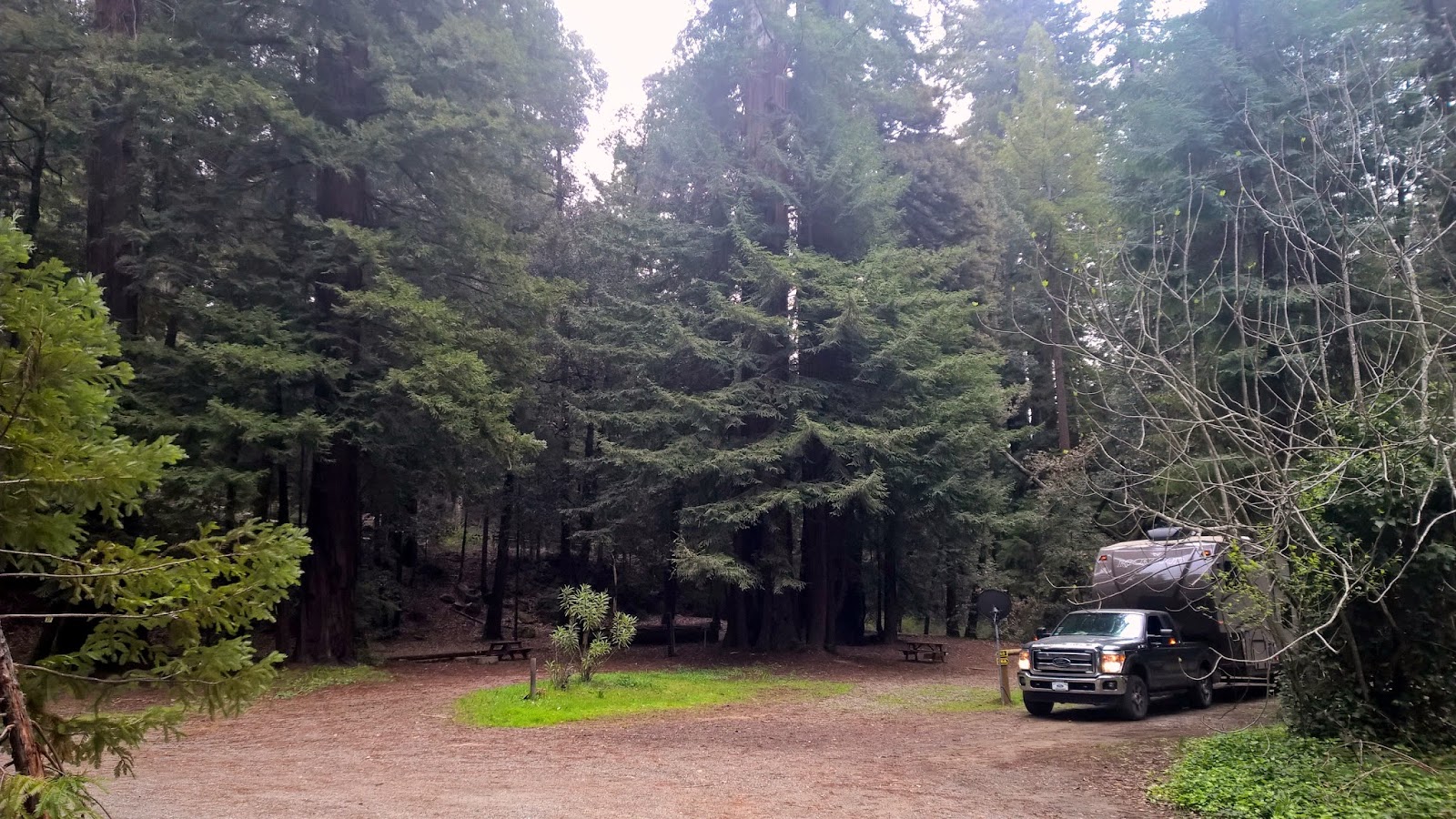
Last look at the campsite under the Redwoods. Hitched and ready to pull out to see new things.

U.S. Highway 101 runs from the Los Angeles area in California to the Olympic Peninsula in the sate of Washington. Sometimes it runs along the coast and other times it is several miles inland. The first half of this trip was away from the coast and in the woods while the last half was along the coast. It is a great feeling when you "pop" out of the woods and see the ocean. It must be close to the feeling a blind person may feel if they are suddenly given the gift sight. It is one of those feelings that sticks with you and I'm sure I will be able to call upon it in the future. Wow.

This right after "popping" out of the woods into the sunlight. Notice the lack of traffic, it was great.
California is very good at providing turnouts or pull-offs at every available location. On the two lane sections of 101 they provide pull-offs so slower vehicles can allow passing. Most of the drivers are very courteous about doing this and the passing cars say "thank you" with a double honk of their horn. There was very little traffic during yesterdays move, probably due to the time of week and the pre-spring season. I don't think I would like to be around here during the summer as it must be lots of traffic and people on this stretch of highway. The temperature was in the upper 50's with very little breeze and an overcast sky. The forecast was for showers and at times I could see darker clouds forming.

This is one of the larger pull-offs. It is probably a parking lot full of cars in the summer since it is right on the beach. But yesterday, I had it mostly to myself as I enjoyed the view. 

My attempt at a trick shot. I tried to catch the reflection of the ocean in the window on Liberty.

Last view before continuing the trip

I found a very nice, reasonably priced campground in Crescent City. I am receiving full bars, 4G LTE connection on my MiFi. It is close enough to the coast that I was able to hear the fog horn through the night. It didn't bother my sleep at all and was somewhat comforting. The campground is one of those that gives me a good feeling as soon as I pull in to register. RV travelers will know what I mean about that. I paid for a week and will let the weather north of me determine if I extend that time or not. 
Campsite in Sunset Harbor RV Park


My plans are to just kick back and let time catch up to me. Moving as often as I do, everything I see and do is brand new to me. That's means my short term memory gets filled up quickly and I need time for those memories to make their way back to my long term memory. In computer terms, it's like downloading something from a flash drive (short term memory) to the hard drive (long term memory). Of course on the other hand, I may be full of crap and my mind just may be messed up. Personally, I'm hoping it is the first case.

After setting up camp, I checked the "local scout" option on my cell phone and found a Taco Bell. Yippee, I'm back in civilization. :) I drove around to get the lay of the land and find some landmarks. They have a nice drive along the beach and I was able to get a few pictures. 

Shore area in Crescent City. You can see the clouds turning darker.

More coastal pictures

Dark sand beaches

By this time of the evening, it was in the low 50's with a good breeze but she was braving the weather to walk on the beach.

Some houses along the coast in Crescent City. Great views.

Ya'll take care of each other. I'll Cya down the road.

Friday, March 20, 2015

Port Cabrillo Light Station and Fort Bragg in CA?

Location: Redwood River Resort (el 850 ft); Leggett, California

(click pictures to enlarge)

Today's exploration was to the Pacific Coast north of Fort Bragg and the Point Cabrillo Light Station. 


This was the view out my door as I was heading for the coast. Those are two very tall Redwoods. The one on the right has a burn scar. With some of these living to be 2,000 years old, it is anyone's guess as to when the fire happened. It is surprising how many have those types of fire scars. Also notice the smaller trees growing around the big one. Those are the offsprings of the big ones. Life begetting life. Nice.
I left the campground and had to drive over two mountains on curvy roads to reach the coast. One minute you're in dense trees and then all of sudden you shoot out into the bright sunlight to see the ocean. It is definitely one of those 'wow' moments. The contrast in scenery between the trees and coast is shocking. You go from being able to see only 20 feet or so to being about to see all the way to the horizon. 


This part of the coast has steep cliffs with very little, if any, beaches. 

The things in the water is remnants of the land many centuries ago. The cliffs are constantly eroding and sliding down into the ocean. The softer material dissolves easily but the hard stuff stays around a long time like what is in this picture.

This is looking north. To the right, outside of the picture, is where Highway 1 leaves the coast and goes inland to intersect U.S. 101 near my campground. The coast road ends here and doesn't begin again until the city of Eureka about 100 miles north. I will be passing through Eureka tomorrow on my way to the next campground.

The triangular rock has a hole in the middle with waves crashing through it.

Looking south, there was a light fog or haze hanging over the land giving it a somewhat eerie look.

Pretty views from many of the turnouts along the road.

This was close to being called a beach but you had to climb down to get to it. Notice the RV's boondocking in the roadside park.

The clouds added a special something to this picture. This is looking south so you can still see the haze/fog.

Pretty view

More waves.


Before getting to the town of Fort Bragg you drive through these coastal trees. (I still haven't found their name)

Fort Bragg in California really isn't a fort and it never was a fort. It started back in 1857 as a place to garrison soldiers to aid in the creation of a nearby Indian Reservation. It is named after the same person as is the real Army base in North Carolina. The man was Braxton Bragg and he held military positions in both the Union and Confederate Armies. Although rising to the rank of General in the Confederate Army, he had a very lackluster career and lost more battles then he won. 

Fort Bragg in California was named after him when he was still a Captain in the Union Army. The Lieutenant that was sent to establish the garrison decided to call the place Fort Bragg after his former commanding officer. The name sort of stuck, even without it being a true fort. Some years later, the Army abandoned the fort as well as the indian reservation. The land on which the reservation sat was subdivided and sold for $1.25 per acre. Although several individuals bought some of the land, most was bought by timber companies to harvest the pine and redwoods. Ships full of the trees were sent south to be used to build San Francisco. On the return trip, the ships were needing ballast to keep from riding too high in the water, so they would bring bricks back to Fort Bragg to be used to help build it's city. This went on for many years. 

Now-a-days, Fort Bragg is a tourist destination with many shops and motels. The tourists come to see the coast and visit the redwoods. It is a pretty nice little town, even though they don't have a Taco Bell. :)

About 6 miles south of Fort Bragg is the Point Cabrillo Light Station. It was built to warn ships about the reefs immediately in front of the point. The ships during that time would hug the coast as close as possible to avoid storms and strong currents. Many wrecked on the reefs and rocks prior to the building of the lighthouse. The "first light" for the lighthouse was in 1909 and it is still being used today to warn ships away from the reefs. It is located on a bluff that is about 60 to 80 feet high. One of the good things about having a lighthouse is the lighthouse keepers logs. They kept very good records about the weather and such. On at least 2 occasions the keepers noted waves crashing over the bluffs and going through the first floor of the lighthouse. Along with the waves, there were 200 pounds boulders thrown around like dice landing near the lighthouse and further inland. It is unknown what caused these very large waves. They did not seem to coincide with any earthquakes or other natural disasters that are known to cause large waves.

Today, you have to park 1/2 miles away and walk to the lighthouse. It isn't too bad going to the lighthouse since it is downhill, but dang, coming back uphill wasn't fun for a fat old man. I'm kidding, it really wasn't too bad at all. I enjoyed the walk, even after getting winded on the return trip. The weather cooperated with temperatures in the lower 60's. 


I found this "thinking bench" on the way. That is the lighthouse in the middle. 

A cove like the one on the right is also on the left. Sooner or later the lighthouse will be cut off from the mainland.

A view from in front of the lighthouse.

Wide view

The clouds and the waves put on a great show. It was spectacular.

There weren't any benches close to the bluff but this picnic table did the trick for me. I sat for a while, hoping to see a migrating whale, but alas, no luck.

Although I didn't see any whales at sea, I did see this seal in the cove next to the lighthouse. That is him laying on the rock, sunning himself in the left side of the picture. I thought he was dead for a while until he moved some.

The last look back as I began the walk back to Freedom.
It was a good day. 

I emptied my tanks when I got back to Liberty and I will be moving tomorrow to Crescent City. Maybe they will have a Taco Bell.


Ya'll take care of each other. I'll Cya down the road.

Wednesday, March 18, 2015

Moving Day, Camped Among the Tall Trees and Future Travel Route

Location: Redwoods River Resort (el. 850 ft); Leggett, California

(click pictures to enlarge)
(pictures taken with Nokia Lumia Icon 929 Cell Phone)

I moved 150 miles north along U.S. 101. I'm camped among a stand of Coastal Giant Redwoods in a little family owned campground. There are maybe 20 other RV's here and of those maybe only 1 or 2 that are travelers. There others are either permanent or semi-permanent. All of the sites are well maintained and you really have to know what you're looking for to tell that they aren't travelers. There are a lot of family friendly things to do in the campground, but they are not open yet since it is too early in the season. I bet this is a happening place in the summer and packed when the kiddos are out of school. 
This peacock was standing on the side of the road as I pulled out of the KOA this morning


I bought something a couple of years ago in preparation of full-timing. I knew I would be traveling in the west so I ordered the Mountain Directory West from Amazon. The directory lists all of the high passes and steep roadway grades for the western states. Basically, it is every roadway grade greater than 5% or curves sharp enough for an 18 wheeler to side track into the opposing lane. I have confidence that Freedom can pull any grades in the Rockies, even with Liberty attached and with her tanks full. Fully loaded, Liberty tops out at 9,000 pounds. I verified her weight at the FROG rally in Goshen, IN last year. Freedom is rated to safely tow 12,000 pounds so that gives us a 3,000 pound cushion. I figure Ford has also underestimated the towing capacity due to some lawyer telling them to do it for liability protection. I don't officially count that extra, but it is lagniappe. The book lets me know what to expect down the road. 


Good book for anyone towing in the west

Typical landscape about an hour north of San Francisco on US 101

We had the rest area mainly all to ourselves.

This is the road inside the campground going to the campsite. Some of those trees are Redwoods, the tallest living things on the planet.

The road goes right between those two Redwoods. There was about 2 feet on each side of Liberty.

Backside of Liberty with a Redwood in the background

Side view to show the size of the Redwoods

That's Freedom and Liberty in the darkness with sunlight filtering through the tall trees

Looking up at the tall guys. It will make you dizzy looking up so high

Looking across the valley from the campground.

I had to back away to get this one

After I got Liberty all set up, I went to get gas for tomorrow's exploration. The nearest gas station is 10 miles north and the nearest restaurant is 6 miles south. I found a few pictures along the way.


A side view of one of the many bridges over the South Fork of the Ell River

The road follows the river through this valley

More river/mountain views

I usually don't take pictures of my food but in this case I wanted to show what these Californians call Cole Slaw. It had broccoli in it with a hint of horse radish. It looked more like something to put on the sandwich than as a side dish. By the way,,,the Rueben Sandwich was great. 
I'll be here for two days. My plan is to drive to Fort Bragg by way of the coast tomorrow. That trip will show me more Redwoods plus I can compare the coast up here to the one down south. 

I'll move again on Friday to Crescent City, CA. It is the last moderate sized city on the coast of California before Oregon. I'll stay there for at least a week. It seems a nice place to let time catch up to me and possible my mail too.

Ya'll take care of each other. I'll Cya down the road.

Tuesday, March 17, 2015

Moving Day, Golden Gate Bridge and Pacific Coast

Location: San Francisco North/Petaluma KOA (el. 60 ft); Petaluma, California

(click pictures to enlarge)

Yesterday was moving day; about 170 miles. Liberty took a beating the entire way from just about each and every bridge. CalTrans has done a very good job on the roads and most are smooth with only a few areas in need of patches. However, they really need to work on their bridge ends. I hit a couple that made me look in the rearview mirror to make sure Liberty hadn't unhitched. I really hope the roads improve as I head farther north in a couple days. 

I moved from one KOA to another which is unusual since I usually don't stay in KOA's. They are full of amenities that I don't need. For example; petting zoo's, bouncing pillow, hayrides, etc. They are usually overpriced for my needs but would be very nice for a family with children. The advantage for me is they are usually located exactly where I need to be to do the exploring I want to do. I'm using this one for access to the Golden Gate Bridge and the Pacific Coast. I also think there is a grove of Redwoods close by which I didn't know about until I checked in here. The campsite was perfectly level both fore and aft which is always good. I haven't counted lately but I think I'm getting close to having stayed in 100 campgrounds and have only had to use leveling blocks maybe a dozen times. Of course there were a few times that I should have used the blocks but I was tired and said that 1/2 bubble would be OK. It is during those time I have to be careful about opening the shower door to make sure it doesn't fling open too fast and hit the vanity counter. 

KOA campsite, electric/water. I will empty my tanks on the way out or since the dump station is in a very bad location, I may just carry the extra weight to the next location.
I packed a lunch today and went to see the Golden Gate Bridge. It is about 30 miles down US 101, which varies from 3 to 5 lanes with an HOV lane. I pulled out of the campground around 9:30 after visiting with a nice couple from Florida in a new Winnebago View. They only stopped for the night and were heading farther north. We exchanged information on places we had been, where we were going, recommendations as to campgrounds to stay in and ones to avoid. After telling each other safe travels and Cya down the road, I headed out as they finished breaking camp. 

Traffic to the bridge was light and I was able to go 60 mph the entire way. I saw a California Highway Patrol motorcycle cop speeding while weaving in and out of traffic without his "bubble gum lights" on. He got about a mile ahead of me before pulling someone over. By the way, those cop lights don't look like "bubble gum machines" anymore, I wonder what they call them now a days. I've heard it called "running hot", but heck that could have double meanings so I don't think I'll use it. :)

You're looking north in this pictures. The bridge is to your right out of the picture. Notice the two tunnel openings to the left/middle of the picture. You come through those tunnels and everything just opens up and you can see the tops of the bridge. As you look in your rearview mirror you will see the tunnel entrances have a rainbow painted around the entrance. 
The bridge is 78 years old and is maintained by a crew of 16 ironworkers and 34 painters. It is called The Golden Gate Bridge because it crosses the Golden Gate Strait, which is the water leading from the ocean to San Francisco bay.
That is Alcatraz Island on the left/middle. It gives you an idea how far the guys who escaped had to go to get to shore. Personally, I don't think they made it although others think they made it safely and lived a normal life afterwards. 
She sure is a pretty bridge.

One of the sad facts I learned about the bridge is that it is the number one suicide location in the world. More than 1500 lost souls have jumped to their deaths. There have been so many jumpers that 11 suicide crisis phones have been installed along the walkway in hopes of helping people. The good news is that more than 30 people have survived the jump. It would be nice to read about what those 30 people did with their lives after God saved them from a foolish act and gave them a second chance. I haven't been able to find that information. 

I found a nice "thinking bench" on the way to the bridge overlook, however it was already occupied. 

After I left the bridge, I went back north on U.S. 101 and exited onto CA 1 which runs along the coast. I figured there would be some nice ocean views. I wasn't mistaken.

Looking southward

Looking north. You can see the highway as it curves around the outcroppings. 

There is a house with a view


A nice walkway has been built out to the point.

There is a bird sitting on the highest rock next to the tree. He stayed there the entire time I spent on the walkway. 

I waited patiently while the two young ladies finished their conversation. I overheard enough to hear that the one on the left was complaining about having to work too much. The one on the right agreed and offered encouragement that things would get better.


After the young ladies left, I enjoyed the end of the overlook. It was nice.

Looking back towards the parking area. Notice the lack of people. Being early in the season is great.

The only true beach area along this stretch of coast. It is about 3 miles long and named Stinson Beach. It was a little chilly for beach time but I can imagine it is packed during the summer time.

I drove through several locations with these trees. Their surfaces are smooth like an Aspen or Birch. Some appeared to not have any bark at all. I haven't researched them to know their name, sorry. 

This was my view as I ate my lunch. Bologna sure tastes better when you have a good view. 

As I got farther away from the coast and coming into to Petaluma from the west, the landscape changed to these rolling hills. There was green grass everywhere and lots of dairy cows.

There were places where only a few cows were grazing. If you look close you can see more cows in the background that are "skylining" themselves at the top of the hill.
I decided to include a selfie with the bridge in the background. 
I'll be heading farther north on Wednesday. The weather has been warm but I keep getting a sense that there is at least one more winter snap to go. I'm probably pushing my luck but I'll continue north to at least the Crater Lake area. If I find a nice campground, I need to stop longer than a couple days to let time catch up.

Ya'll take care of each other. I'll Cya down the road.